CURRENT GRAND MARAIS SCENES: February 2008

This has certainly been an “old fashioned” winter. There has been one blizzard after another. It is a good thing that I am a cross-country skier who enjoys being outside in the winter. For if not, I would have missed just how beautiful the winter has been. One of the blizzards blew for over 30 hours with winds up to 66 mph (measured at the light house at the end of the breakwater), and a chill factor of 45 degrees below zero. The blizzard was so intense, that it completely coated the branches of the evergreens. Pictured below are two of my ski friends, Dianna Bell and Sandee Sibald on the backside of Trail B in the national park.

The great amount of snow has started to pile up on shore. Last weekend, a few of us skied in the School Forest out to Goebel Beach. There are three distinct rows of icebergs. Some of the bergs appear to be around 30 feet tall! With much more of winter to go, it is going to be fun watching the icebergs grow.

Although I prefer to ski, one nice thing about snowshoeing is that you often come across scenes with snow that has not yet been walked on. This is a shot I took of the bridge that is across Sable Creek between Sable Falls and the sand dunes, on the way to the Ghost Forest.

While skiing my property late one night, I experimented with taking pictures of icicles hanging off my house.

CUSTOMER AGATE FINDS: January 2008

Although the Grand Marais area did have snow in December, the relatively warm lake temperatures allowed rockhounds to agate hunt during most of the month. This 3.3 ounce agate was found by Jody Patton, from Curtis. She and her husband, Jim, dropped it off a couple of weeks ago and asked me to face polish it. Once I saw the specimen, I eagerly urged them to do so since it is a marvelous shadow agate. In the rough, you could tell that it would shadow but the optical quality was only fully visible through polishing. Congratulations, Jody, for finding this terrific Laker in December!

History’s Gem of the Month: Grand Marais Tourist Signpost

January 2008

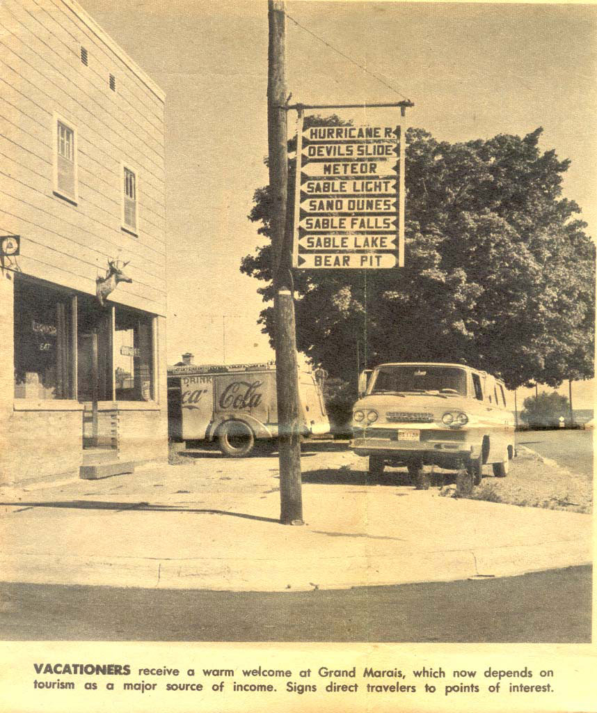
For those of you who lived in or visited Grand Marais during the 1960s, you probably remember the signs that were displayed on the pole outside of the Dunes Saloon, now called the Lake Superior Brewing Company. The founder of the museum Axel Niemi, was actually one of the movers and shakers that helped develop Grand Marais as a tourist destination. During that time, he managed Woodland Park and helped to develop tourism-related resources to draw more people to the area.

We are not sure exactly when the signs were put up, or when they were taken down. Most likely the Chamber of Commerce was responsible for installing them.

All in all, though, it was nice to run across this newspaper clipping and include the photo as this month’s History Gem. I remember many a summer evening when us kids hung out in front of Kozy Corner across the street from the sign post. We watched tourists try to read the signs and figure out what Grand Marais destinations they wanted to check out.

MINERAL OF THE MONTH: January 2008 Native Copper


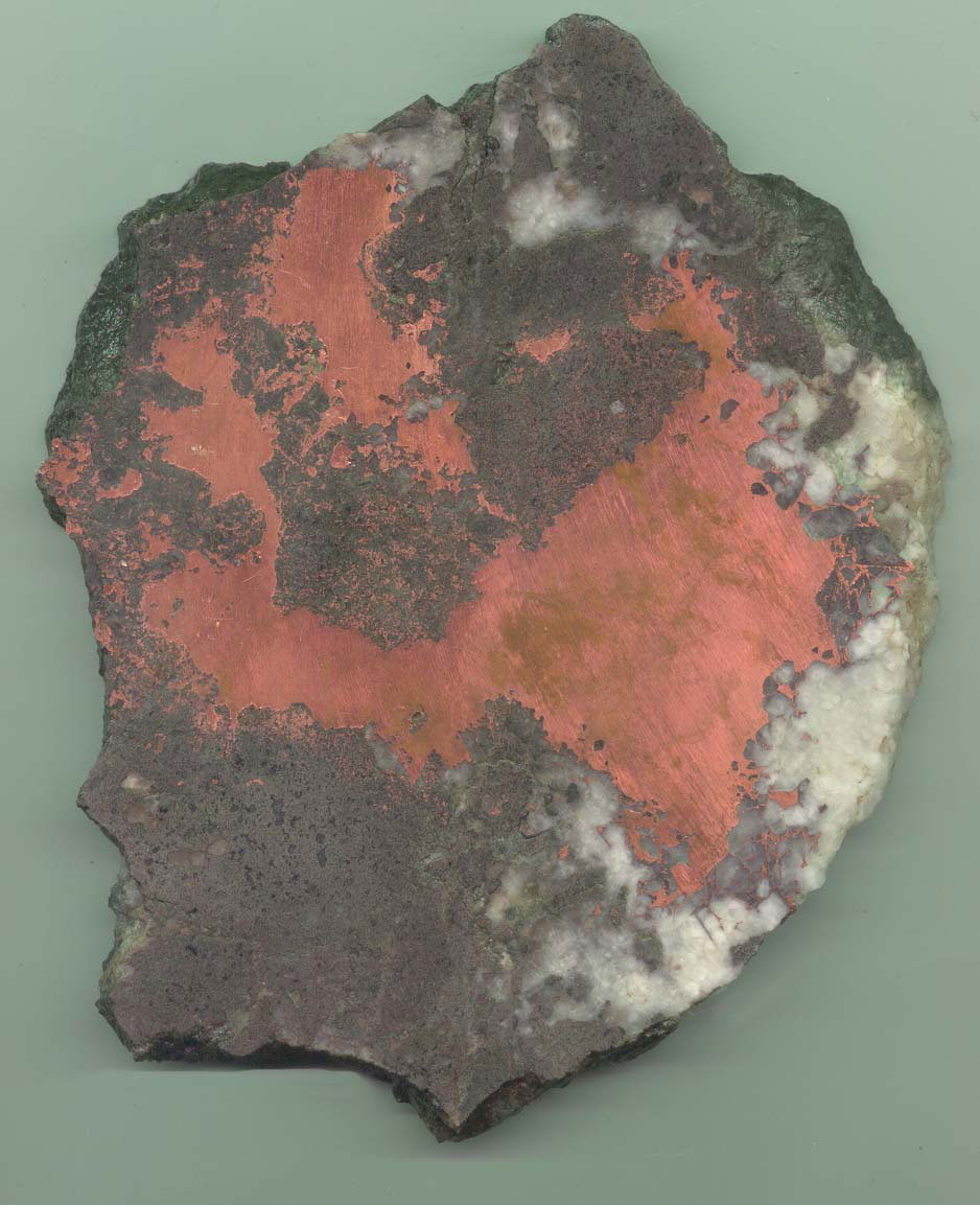
January’s mineral of the month is native copper. This interesting specimen was recently donated to the museum by Peter Pagel, from Marquette. He acquired it from the Houghton area. It is a thick slab of native copper in matrix that is 7 inches by 6 inches.
This specimen was mined from the Keweenaw Peninsula, which is the greatest native copper ore deposit ever found on earth. The deposit formed in the Mid-continent rift zone around a billion years ago. Native Americans have been mining the ore since around 3000 B.C. The first written account of copper was provided by French missionary Claude Allouez in 1667. He recorded that Indians of the Lake Superior region mined copper nuggets in shallow depressions. It was these abandoned pits that led early American prospectors to the sites where successful mines were later established. Large scale mining operations began in 1844 and continued until the 1960s when open pit mining out west became more profitable than underground mining.

The first person to report on the commercial potential of the copper deposit was state geologist, Douglass Houghton, in 1841. The Cliff mine, which was the first copper mine establised in Michigan, began operations in 1845. Copper mining in northern Michigan boomed, and from 1845 until 1887 (when it was exceeded by Butte, Montana) Michigan was the nation’s leading producer of copper. In most years from 1850 through 1881, Michigan mined more than three-quarters of the nation’s copper, and in 1869 produced more than 95% of the country’s copper. Annual production peaked in 1916 at 266 million pounds. Most of the native copper mines shut down in 1968, after producing 11 billion pounds of copper. The White Pine Mine operated until 1995. The only mine still mining copper on a small scale is the Caladonia Mine, located 20 miles northeast of Ontonogon. The mine’s owner, Richard Whiteman, has a worth-the-stop gift shop in Ontonogon called the Gitche Gumee Landing, located at 202 Ontonagon Street, 906-884-6618, www.caledoniamine.com.

The Keeweenaw deposit occurs in an area around 110 miles long, 10 miles wide, and up to a 1,000 feet deep. Throughout this area, there are amgadaloid (basaltic pocket) deposits as well as veins with copper ranging in size from microscopic grains to very large masses of up to around 1,200,000 pounds. Float copper specimens can also be found throughout the Midwest that were scraped free and deposited by Pleistocene glaciers that scoured the Keeweenaw Peninsula during the various ice ages.

One of the most interesting facts about the Keeweenaw copper is that it occurs in a fairly pure metal form called native copper. Most of the other copper deposits in the world form as copper oxides or copper sulfides that require processing to extract the copper.

Copper is a chemical element with the symbol Cu and atomic number 29. It is used extensively as an electrical conductor, heat conductor, building material, and component of various alloys. Copper is a reddish-colored metal that has its characteristic color because of its band structure. In its liquefied state, pure copper appears somewhat greenish, a characteristic shared with gold. When liquid copper is in bright ambient light, it retains some of its pinkish luster.

Civilizations in places such as Iraq, China, Egypt, Greece, India and the Sumerian cities all have early evidence of using copper. A copper pendant was found in northern Iraq that dates to 8700 BC. During the Roman Empire, copper was principally mined on Cyprus, hence the origin of the name of the metal as Cyprium, “metal of Cyprus”, later shortened to Cuprum. High demand relative to supply has caused the price of copper to spike during the last few years.

Metaphysical Properties

It has been reported that copper is an excellent conductor that amplifies thoughts, boosts confidence, and facilitates healing. It has been used to treat arthritis as well as other inflammation and circulatory diseases.

CURRENT GRAND MARAIS SCENES: January 2008

If you have never been on the shoreline of a Great Lake when the lake-effect-snow-making machine cranks up, then you have missed an exciting weather experience. Most people don’t like snow, especially when it is coming down in a white-out event. However, the experience can be intense, as long as you don’t have to drive. (Note: See more information about lake-effect snow below.)

Lake-effect snow has certainly hit the Grand Marais area this past few weeks. Pictured below are some shots I took on January 26th during a snow-shoe from the Sable Visitor’s Center, along Sable Falls (Second) Creek, to the Lake Superior shoreline and back. In the summer, you can complete this 2.8 mile round-trip hike in an hour or so. In the deep snow, it took me almost 3 hours! It was grueling and more of a work out than I bargained for, but it was worth it!

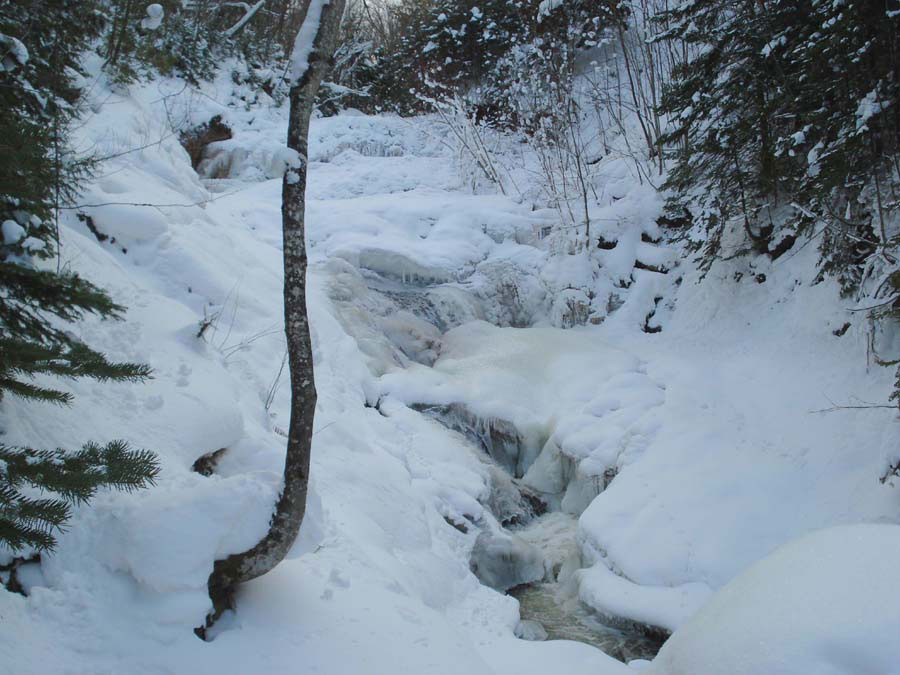
The first picture is of Sable Falls Creek, about half-way between the visitor’s center and the falls. In some places, the river’s current creates enough friction to prevent freezing, while in other places the river completely freezes over. Note “Casper” hanging on the branch in the lower right hand corner of the first picture. In places where the river is frozen over, beautiful ice swirls can form from the influences of the river’s current.

Compare the picture of Sable Falls below, with the one included in the fall. What a difference! The heavy snows and cold temperatures definitely created this natural ice sculpture!

Because I have been busy, I have not had time to get down to the beach since before the lake-effect snows began. I wasn’t sure what to expect, especially since people were finding agates only a few weeks ago. No longer. Not only does the snow pile up on the beach, but the snow that falls into the lake sometimes forms slush, which is piled up into icebergs by the waves. This picture was taken right at the mouth of Sable Falls Creek, looking west toward the Log Slide. You can see the first row of icebergs that have formed just off-shore. Some of them are already almost 20 feet tall. This could be a great year for big picturesque icebergs! That is good news for all you rockhounds. Once they form, icebergs can break off with a stiff south wind, get blown to distant beaches, gouge up rocks as they are shoved to shore, break off again with another change in wind direction, and end up deposited on our beach in the spring to melt with their new load of rocks.

Lake-Effect Snow

Lake-effect snow occurs when you have a cold air mass that blows over a large body of water with a significantly warmer temperature. A convection occurs wherein the warmer air with its moisture rises. As it rises, the water vapor condenses to form clouds. As the clouds reach the colder landmass downwind, the moisture is squeezed back out of the clouds in the form of snow.

Lake-effect snow squalls occur during late fall and early winter when cold arctic air blows over long expanses of warmer lake water. The areas that receive lake-effect snow are called snow belts. Although this weather phenomenon occur at several places in the world, it is best known on the southern and eastern shores of the Great Lakes.

There are several characteristics that impact lake-effect snow:

  1. Temperature Difference: To produce lake-effect precipitation, the temperature of the air mass must be significantly colder than the temperature of the water. The greater the difference, the more the instability and the higher the potential for developing snow. Usually the temperature difference must be at least 30 degrees to create lake-effect precipitation.
  2. Fetch: The fetch is the distance across the lake that the air mass moves. The greater the distance, the more chance there is for heat energy and moisture to transfer from water to air, thus, increasing the amount of precipitation that can be produced. Usually the fetch must be at least 60 miles to produce lake-effect precipitation.
  3. Wind Shear: Wind shear refers to variation of wind speed or direction. When there is a weak directional shear (less than 30 degree change of direction), well organized bands of clouds form resulting in greater amounts of lake enhanced precipitation. If the directional shear is between 30 and 60 degrees, weak lake-effect bands are possible. If the directional shear is greater than 60 degrees, nothing more than flurries is usually produced.
  4. Wind Speed: The higher the wind speed, the farther inland will be the potential for lake-effect snow.
  5. Topography: The speed of wind offshore can be nearly double the wind speed observed onshore. This is caused by the differences in friction between land and water. When wind is blowing over water, there is less friction compared to when wind blows over land. Thus, the more complex the topography is onshore, the more friction there is, and the more the wind is slowed down which can increase the amount of lake-effect precipitation. Also, the higher the elevation on shore, the more the moisture is squeezed out of the lake-effect clouds.
  6. Ice Cover: As the lake gradually freezes over, the potential for lake-effect snow is lessoned. This occurs because the liquid surface of the lake shrinks reducing the potential for transferring heat and moisture to form lake-effect clouds. Also, as the lake temperature drops, the temperature difference between the lake and the air mass decreases, thus, reducing the instability and limiting the energy that can “fuel” the lake-effect machine.

The amount of lake-effect snow produced depends upon all of the factors listed above. If the conditions are right, up to 10 inches of snow have been known to fall per hour. This month in Grand Marais, we have received almost three feet of lake-effect snow. One of the record lake-effect snow events ever recorded occurred in Buffalo, NY between December 24th and 28th, 2001 during which 82.3 inches of snow fell!

The impact of the lake-effect machine can especially be seen in the Lake Superior region. Snowbelt areas in the Keeweenaw and near Grand Marais average over 250 inches of total snowfall each year. Duluth, MN, which is not impacted by lake-effect due to its proximity on the western shore (protected from the predominant northwest winds), averages only around 77 inches per year. Also, in any single storm, Grand Marais can receive a dozen or more inches of snow, while Seney, located 25 miles to the south, receives none.

History’s Gem of the Month: Lake Superior Editorial

December 2007

This month’s History Gem continues with the Lake Superior information theme. Recently, I received an email from David J. Krause, a geology professor from Ann Arbor, MI. He is a UP enthusiast who wrote the book “The Making of a Mining District” about the history of copper mining in Michigan. David’s wife is from Ontonagon, where her father named a fish tug after her and her cousin: the Sheryl-Dennis. In fact, as David reports, for some years the tug belonged to Grand Marais fisheries.

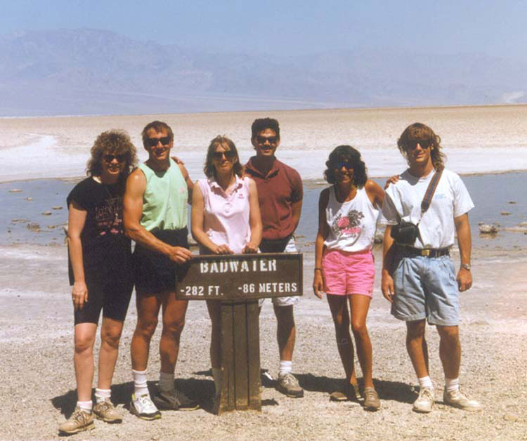
Through a mutual friend, he found out about the web page and the Gitche Gumee Museum. He sent me an email to tell me about his campaign to have Lake Superior officially designated the lowest point in North America. In his email, David reports: “I am dead serious about getting this information out and the need for correcting the “Death Valley thing” thrown around by national people who should know better. For many years I made sure that everyone who took my geology class understood it. The Death Valley defenders will likely argue that the bottom of Lake Superior is under water, but this is a non-issue for several reasons. Death Valley (Badwater Basin) is itself a lake during part of some years, and the fact that the Lake Superior basin happens to hold fresh water (not marine salt water) is irrelevant to its structure.”

In his campaign effort, David sent the following letter to the National Geographic Magazine:

Editor, National Geographic Magazine:

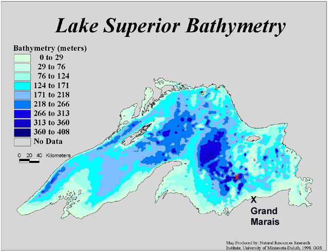
Your article on Death Valley (Nov 2007) includes a photograph with a caption that states: “At 282 feet below sea level, Badwater Basin is North America’s lowest point.” This is not correct. Lake Superior currently occupies what is by far the lowest structural basin on the North American continent. The surface elevation of Lake Superior is usually cited as about 602 feet above sea level and the depth as about 1333 feet, leaving a bottom elevation of 731 feet below sea level. This point lies about 40 miles north of Munising, Michigan, and therefore falls within the borders of that state. Therefore, the lowest point on the continent of North America is the bottom of the Lake Superior structural basin, being nearly 450 feet lower than the minus 282 feet of Badwater Basin (which itself may be under water or not, depending on local climatic conditions).

One further point I would like to make is that I believe the sign at the Badwater Basin says that it is the lowest point in the Western Hemisphere. Thus, Lake Superior is actually the lowest point in the western hemisphere. The photo below show the deepest point in Lake Superior, which is not very far from Grand Marais. I’ve also included a photo of my hiking friends and I that was taken at Badwater in Death Valley. This was a vacation we took in the early 1990s wherein we hiked Mount Whitney (14,496 feet), which is the highest point in the continental U.S., and went to Badwater (-282 feet) within the same 12-hour period. On that trip, we also went to Las Vegas and stayed a night in the hotel on the Queen Mary. We called it our “vacation of contrasts” trip. In the photo, I am on the left.

MINERAL OF THE MONTH: December 2007 Nepheline Syenite

In keeping with the latest web page effort to provide information about the Lake Superior basin, this month’s Mineral of the Month is Nepheline Syenite.

Nephelene syenite is an igneous rock that consists largely of nepheline and alkali feldspar. The rocks are mostly pale colored, grey or pink, and in general appearance they are not unlike granites, but dark green varieties are also known.

Nepheline syenites typically are formed by low degrees of partial melting in the Earth’s mantle, very often in plate tectonic subduction zones. It also forms in the magma chambers of volcanos, such as that which is found on the eastern shore of Lake Superior in the Coldwell Alkaline Complex. This geologic structure consists of a curcular plug of rock, much different than any other rock in the area. It is over 15 miles in diameter, stretching from the Little Pic River to the town of Marathon.

Syenite is a rare rock in the Earth’s crust. Nepheline syenite is even less common. It has a hardness of 6, specific gravity of 2.57, and weighs 160 pounds per cubic foot. Depending on where this rock forms, it can contain up to 12 elements. The Nepheline Syenite found in Ontario formed in the middle Proterozoic age, just over 1.1 million years ago.

Nepheline syenite has become preferred to feldspar as a source of alumina and alkalis for glass manufacture. It promotes more rapid melting at lower temperatures, thus reducing energy consumption, lengthening the life of the furnace, and improving the yield and quality of the glass that is manufactured. The material is also used in ceramic glazes and enamels and in fillers in paints, papers, plastics, and foam ruber. Its solid nature enables it to be used in the building industry to make huricane and fire-proof buildings, roofing material, and decorative stone. It is also used to make self-sealing glass containers to transport nuclear waste products. Canada was the first country (1932) to develop the use of nepheline syenite as a raw material for glass, ceramic, and filler industries.


CURRENT SCENES OF GRAND MARAIS: December 2007

Unlike last year when we had almost no snow until the third week of January, winter has started early this year. The pictures in this update include a couple taken in November on a hike to Au Sable Lighthouse. The first is an interesting picture of the lighthouse, with a late fall sun angle. The second features one of my favorite views of the Grand Sable Banks, taken from the beach east of the lighthouse.

In late November and early December, my friend Scott and I started training to get in shape for this winter’s cross-country skiing. Before the sand froze, this was not a problem. However, the two pictures shown below were taken on a dunes hike that proved to be quite challenging. It is not at all easy to walk up and down dunes when the sand is frozen. Winter dunes scenes, though, are quite picturesque and worth the hiking difficulty!

While returning from the Gitche Gumee Gathering private art show in Marquette last weekend, my friend Renee Beaver/Stocking and I stopped by Munising Falls to check on the progress of ice formation. We were not disappointed. A team of artists could not do a better job than nature has to sculpture both the river and the falls!


CUSTOMER AGATE FINDS: Fall 2007

The fall update features another reappearance from the original web page. Earl Johnson, from Newberry, MI, and his wife spend most of the summer in Grand Marais agate hunting. While they were on the beach, they spoke shortly with my friends, Gerald and Jill, who I go to Moose Lake with each July. Gerald, with his wet suit on, was kneeling in the shallow water. Soon after he swam off, Earl looked down to the spot that Gerald was kneeling and found this large one-pound peeler! Earl asked me to face polish the end, which had great results!

George and Marion Curtis, of Grand Marais, were visited by their son Jeff and family from British Columbia. Pictured below are Jeff, and daughter, Katie. While here, they found this 2-½ pound specimen. From the outside, it was difficult to tell exactly what was going on so they asked me to cut a slab off the end. We were surprised to see this unusual, paisley moss agate.

Each summer the Newago Rockers come to Grand Marais to agate hunt. It seems that the group gets larger each year as the rockhound “virus” spreads. Pictured below are some of the agates that Gretchen Fairnosi and family found this year.

One more agate found early this fall was a gray/white shadow agate by Rick Waml. What is interesting about this agate, which I face polished, is that it appears to be similar to a Botswana agate. In fact, I would have bet on it so either someone seeded the beach with a Botswana agate, or most likely, this specimen shows how similar agates from different locations can be.

History’s Gem of the Month: Tourist Information from the 1920s

Fall 2007


Last year, a couple of boxes of Grand Marais memorabilia were donated to the museum from the John Strom family. Included were several newspaper clippings going back to the 1920s, as well as some old post cards, logging equipment, and other items. The following article, written by Robert Page Lincoln, was published in the Minneapolis Tribune. In that this article mentions many areas that no longer exist, it must have been published during the 1920s. The post cards included below also were from the same era, or earlier. Notice that the Munising picture has almost no houses or other structures. Also, the Sable Falls picture shows a falls that is very much different that what we see today. Compare this picture with the one included in this month’s Grand Marais Scenes.

Outdoors . . .

Without doubt, Alger County, in the upper peninsula of Michigan, contains more attraction per square mile than any other section of the state. Here are a list of the attractions that are of interest to the traveler and outdoor lover:

  • The world famous Pictured Rocks of Sandstone.
  • The bathtub of the gods on William’s Island.
    • An enormous “tub” in the rock about 100 feet long and 30 wide.
  • Miner’s Castle
    • From the top of which Father Marquette preached to the Indians in their birch bark canoes below. On top of this rock can still be seen a rugged cross cut in the face of the sandstone and beside it a bowl hollowed out of the rock for the holy water.
  • Caves of the bloody chiefs
    • Where the Indians placed their prisoners of war, with such a thing as escape impossible.
  • Virgin’s rock and Bridal Wreath Falls.
  • The gigantic caves on Grand Island.
  • The remarkable grandeur of the shifting sand dunes of Grand Marais.
  • Remains of ancient iron furnaces near Munising, and the ancient charcoal kilns near Onota.
  • The enormous meteor at Star Siding on M-28, just a few miles from Munising.
  • The 200-foot glacial pothole on Perch Lake trail out of Munising.
  • Cox’s trout pond at Wetmore
    • The only inland body of water in the Upper Peninsula that flows both into Lake Superior and Lake Michigan.
  • Ancient Indian burial grounds on Sandpoint.
  • The location of Munising Bay
    • “Where stood the wigwam of Nokomis, daughter of the moon and grandmother of Hiawatha.”
  • Grand Island
    • The home of the elk and albino deer, where the renowned George Shiras III, famous wild life photographer, experimented with almost all of his night photography of wild life. … Grand Island is one of the most unusual islands in the United States, second only to Isle Royal, having 40 miles of shoreline, 13,600 acres of virgin timber.
  • The ancient fur trading posts of the American Fur Trading Company
    • Still standing, with fur derrick intact. Au Train, the resting point for the dog teams that carried the mail on one of the first mail routes to be established in the Upper Peninsula. Peter White was the mailman. The beautiful Adam’s Trail, one of the finest drives in the Upper Peninsula.
  • The Cusino Deeryard
    • Ranked as one of the largest deeryards in the United States.
  • The Hiawatha National Forest
    • One of the government’s most ambitious efforts in Michigan. It has considerable wilderness that is untouched by either fire or the axe of the lumberman. The vast pine plantings in this forest which are a study in themselves and might well be studied by foresters elsewhere.