CURRENT GRAND MARAIS SCENES: October 2008

One of my favorite times to hike in the Upper Peninsula is during the fall season. Not only do the arboreal colors add to the splendor, but there are usually no other hikers and no bugs.
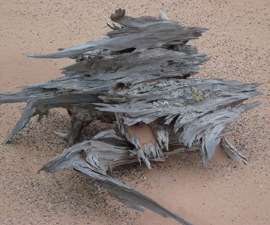
The first picture featured this month is a Ghost Forest stump. The interpretive sign near Sable Falls’ dune walk speaks about the Ghost Forest. The forest that used to be near that sign is almost disintegrated due to weather and tourists taking souvenir pieces. Thankfully, there are several other Ghost Forests sprinkled throughout the dunes. This is an amazing stump now exposed but previously protected by the sand for several thousand years.

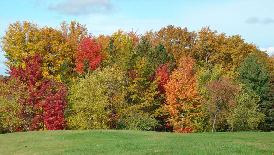
Although I included a fall picture last month, I have to also include the photo below. For what ever reason, the fall colors this year were significantly better than they have been in other years.
While attending the first annual agate festival held at Muskellunge State Park, I took an extra day to go agate hunting with my friend, Renee Beaver, at Vermillion Beach. I had never been to that beach before, which is located west of Whitefish Point. It is unusual and different from Grand Marais’ beaches in that the entire beach is covered in a cobblestone-like fashion with flat rocks. The type of rock is similar to that found in Grand Marais, but there are also a large number of golden-colored microcrystaline specimens — some of which that have water-level type banding.

There is also a lifesaving station at this site. This station, along with 3 others at Crisp Point, Deer Park, and the Two-Hearted, were constructed in 1876. Vermillion was known as Station #9, and was opened on May 15, 1877. The station housed the keeper and his family, a crew of 6 to 8 surf men, supplies, life-saving equipment, and guests. The purpose of these stations, of course, was to render assistance to ships in distress and save the lives of sailors on those ships. Even though the southern shore of Lake Superior is known as the “graveyard coast,” these life saving stations were responsible for saving hundreds of lives.

In 1888, the state’s largest cranberry farm was established in the marshes behind the station. A small town grew in the area and included its own post office and school. The station remained active, but was acquired by the U.S. Coast Guard in 1915. It became a Coast Guard station in 1939 and was operated until 1945. After decades of abandonment and abuse, as well as theft from vandals and souvenir hunters, the property and more than a mile of beach was purchased in the early 1970s by Evan Nayes. Nayes and the Wildshore Foundation spent years and considerable effort to restore the facility. During this time, and continuing in the 1980s, Lake Superior State University used the facility to conduct research and classes about history and ecology in this fabulous lake-side setting. The Whitefish Bird Observatory has also used the facility in recent years. In February 2007, the Little Traverse Conservancy purchased the property. They hope that this incredible place will continue to provide solace, knowledge, and awe for many generations to come.
CUSTOMER AGATE FINDS: September 2008

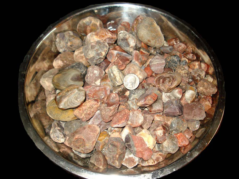
Many of you who know me are aware that I do not get much time to go out agate hunting. However, when I do go out — especially when I go to Minnesota, I am able to put my knowledge to use. My poor eye sight requires that I get close to the rocks in order to see them. Of course, I always have my 10 power “eyes” on while agate hunting. Usually, I dig to get down to layers that others may not have searched. At the request of many museum patrons, I have included a picture of the bowl of agates I’ve found so far this year. I wish I could say I have found a “fister”, but so far one has eluded me.

My friend, Renee Beaver, also makes a repeat visit to the web page. Earlier this month she headed to the beach after one of the storms. Some storms cover the rocks up and/or undertows them back into the lake. However, other storms mix up the rocks to perch new agates up on top. Apparently, the storm that preceded Renee’s agate finds was a GOOD storm. She found 16 good agates — which for Grand Marais is a great day!


ROCKHOUNDING AND ADVENTURE TRIPS: September 2008

Dear Web Page Visitors:

This information was sent to me via an email. I have reproduced it here for those of you who would like to preserve the ability for people to continue rockhounding and are willing to get involved to protect this right.

The habitat of the rockhound is diminishing at an astounding rate. More and more of its free roaming areas are being gobbled up each and every day by the changing environment. Soon the range of the Rockhound and its offspring the Pebble Pup will become so diminished that extinction will be imminent. As the environment changes, the ecosystem of the rockhound is slowly being replaced by the ecosystem known as “Wilderness”, which is a poisonous dead zone for the Rockhound and Pebble Pups. Soon they will go the way of the Smilodon, the California Grizzly Bear and the now extinct Naugas (which were hunted late in the last century for their hides that were used exclusively in the creation of the Bean Bag Chair).

What can be done to save the ecosystem and the fee range habitat of the endangered Rockhound and Pebble Pups? We can do a lot if we ban together and take action now, before it is too late. We need to review all the facts, formulate a plan, distribute the plan and then execute the plan by contacting all of our elected representatives with our facts, figures and recommendations for saving the ecosystem of the rockhound.

Currently before congress there are several new wilderness bills and one bill that will make some fossil collecting and ownership a federal crime. The California Wild Heritage Act and The Eastern Sierra and Northern San Gabriel Wild Heritage Act when passed by Congress could reduce the ecosystem of the rockhound, just in California, by around 3.26 Million acres of new wilderness habitats. The Paleontological Resources Preservation Act when passed by congress will make the collecting and ownership of vertebrate fossils found on public land (BLM, USFS, and State land) a federal crime with punishment with fines and/or imprisonment. Collecting of these fossils on private land is allowed with the proof of collecting on the holder of the fossils. There needs to be allowances for the collecting, ownership and public display of these vertebrate fossils by the amateur collector without the fear of criminal prosecution or civil legal action. We all understand that significant finds like “Sue” need to be preserved for all to enjoy, but the collection, ownership and public display of smaller finds of non-significant, non-descript vertebrate fossils should be allowed in the legislation.

If we do not get involved and take a proactive approach the above legislation will become law and the Rockhound and Pebble Pups will become extinct just like their ecosystem and free range habitat.

So what can we do? First read the proposed legislation, determine the effect of the legislation in your collecting areas. Inform all of your club members of the urgency of the legislation. Formulate a response with recommendations that are attainable. Write letters to your elected officials and present your case and points. If we do not make our voices heard we will loose the battle of the Rockhound and we will become extinct. We can make our voices heard in Washington by supporting and joining the American Lands Access Association (ALAA) as clubs or as individuals. http://www.amfed.org/ALAA.htm.

Below are the Bills and their authors with links to the websites where full information on their status can be obtained.

I have copies of all the above bills in MS Word format. If you or your club would like copies please send me a note with your email address and I will send them to you.

John Martin
California Federation of Mineralogical Societies
Public Lands Action Committee – South
Palmdale Gem and Mineral Club
smartin@antelecom.net
pgmc@antelecom.net

History’s Gem of the Month: Pictured Rocks National Lakeshore Proposal Proposal Part 4

October 2008

Access and Circulation

A scenic road would make accessible much of the now remote shoreline and permit visitors to tour the entire length of the park. In places, this road would run along the rim of the uplands overlooking the important natural and scenic areas, leaving them road-free yet visible. Associated trails would lead into these areas (Minors, Chapel and Beaver Basins). Spurs to the main road would take the visitor to other superb vistas, important features, and within a short walking distance of waterfalls.

A trail system, complementing the interpretive road, would provide unlimited opportunities for exploring the lakeshore. This system would traverse the area from east to west, but shorter loop trails would also be provided. In most cases, the trails would be completely away from roads, particularly in the Miners Basin, along with the Pictured Rocks from Mosquito Harbor to Chapel Beach, the Beaver Basin, Au Sable Point and the Grand Sable Dunes.

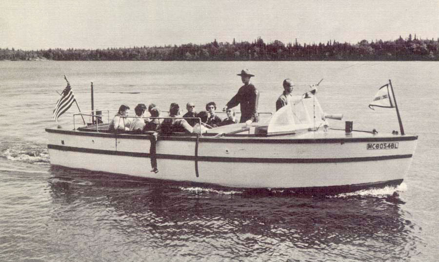
An important means of viewing the scenic features of the shoreline would be by excursion boats plying the offshore waters of Lake Superior.

Camping and Picnicking

Visitors could enjoy the national lakeshore through camping and picnicking experiences. Three campgrounds available by road are proposed, the major one along Pine Bluff Beach. Here, vegetation, substratum, exposure, and proximity to Lake Superior are favorable factors. Other campgrounds are proposed for Grand Sable Dunes and Miners Basin. Four primitive campgrounds containing Appalachian-type shelters are planned to serve hikers. Tentative, these sites would be at Mosquito Harbor, Beaver Lake, Pine Bluff Beach and Au Sable Point.

Beach Use

Swimming in the cold (54 degrees) water of Lake Superior is never likely to be a popular pastime for any but the hardiest. Nevertheless, swimming is possible in several places. The shallow waters along the sandy west shore of Sand Point are currently used by swimmers. The small beach at the north end of Grand Sable Lake is and could continue to be, used for swimming in conjunction with a proposed contact station; picnic ground and dunes access point.

The wealth of sandy beaches in the proposed Lakeshore provides space for several beach uses. Twelve miles of undeveloped beach stretch between the east end of the Pictured Rocks and Au Sable Point, and would be available for beachcombing, hiking and sunbathing.

Boating and Canoeing

The open waters of Lake Superior are too dangerous for small boats but some of the inland lakes should be excellent for boating and canoeing. Water skiing and boating on Grand Sable Lake and canoeing in some of the more remote lakes could be popular activities for lakeshore visitors.

Hunting and Fishing

Fishermen now seek the streams and lakes in the Pictured Rocks Region because the combination of cool climate and good supply of pure water makes them excellent for trout and pike. Fishing is especially popular when the steelhead trout swim up the streams in the spring to spawn. Hunting for rugged grouse, whitetail deer and other game in season would be permitted in designate areas in accordance with Federal and state laws, except in zones which the Secretary of the Interior may designate for reasons of public safety, administration, or public use and enjoyment.

Winter Use

People would visit the Pictured Rocks National Lakeshore in the winter to participate in a variety of recreational activities. Some of the inland lakes are ideal for ice boating and fishing. The Beaver Basin area could provide opportunities for tobogganing and downhill and cross-country skiing. Also, wildlife can be observed throughout the winter season. Another recreational activity that could occur is winter camping. Many people also would probably visit the lakeshore to view the northwoods winter landscape from the scenic drive.

Interpretation

The quality of the visitor’s experience depends upon the degree and depth to which he understands the various aspects and interplay of all the values within the lakeshore. To assist the visitor’s enjoyment of recreational opportunities and in recognizing and understanding the region’s natural values, the National Park Service would conduct an interpretive program on the Pictured Rocks National Lakeshore. Such a program should result in a rewarding experience for all lakeshore visitors.

In initiating an active interpretive and educational program, the National Park Service would employ various techniques — information centers, contact stations, interpretive drives, nature trail’s, signs and slide talks. The interpretive drive would introduce the visitor to the entire range of large-scale features. Specific aspects of the lakeshore could be interpreted by nature trails, conducted walks, slide talks, and campfire programs. Plants, birds, animals — or any other topic that is diffused throughout the lakeshore — would be identified and described in slide talks. Biological units and groups of features in place, which could include geology, plants or animals, would be displayed and interpreted by nature trails. Initially, two nature trails are proposed: one on Sand Point with its combined features of bluffs, ponds, and sandy pineland, and the other south of Pine Beach in an unusually interesting pineland bog. Eventually, two more could be provided — one in a mature hardwood stand and the other in the forested part of Grand Sable Dunes.

MINERAL OF THE MONTH: September 2008 Mohawkite

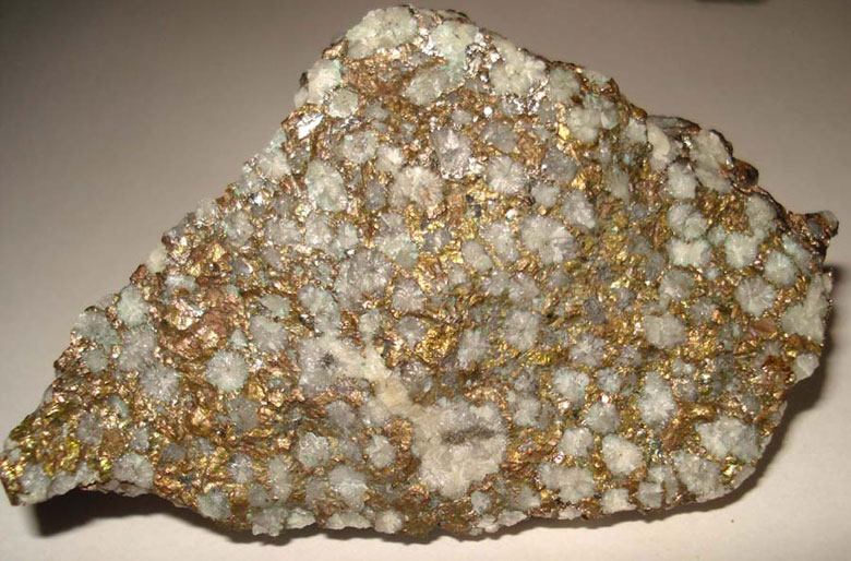
Technically “Mohawkite” is not a mineral but is a combination of copper arsenates with nickel and cobalt. It is also considered a variety of Domeykite. It is named after the original locality: the Mohawk Mine located in the Keeweenaw Peninsula of Michigan’s Upper Peninsula. This is the only location in the world that Mohawkite is found. The cubic crystals are rare in that the mineral more typically forms in masses, especially filling veins in hydrothermal vents. On a freshly fractured or mined surface, it appears whitish, but quickly tarnishes to brown. Sometimes the oxidized surface appears to have iridescence as it tarnishes. It has a hardness of between 3 and 3.5 with a specific gravity of between 7.2 and 7.9. It has a metallic luster with a brownish streak. Because of its speckled formation and combination of minerals, it has an uneven fracture. It is believed that the nickel arsenides crystallized first at higher temperatures. Later, fracturing occurred and some of the nickel was replaced by the copper arsenides-bearing solutions.

CURRENT GRAND MARAIS SCENES: September 2008

Although September has still been busy with shows and custom orders, I have continued to hike in the dunes as much as possible. The goal this hiking season is to walk on all of the ridges in the dunes and with the hike yesterday, that goal has been completed. Next year, I want to try to walk and follow the original telegraph line from Grand Marais to Au Sable Lighthouse. In my various hikes, I have seen dozens of telegraph poles: some of which are still standing. Most of them, however, have fallen after more than a hundred years of blowing and shifting sand. Below are a couple of pictures of two of the poles I found yesterday as well as a shot of Au Sable Point taken from the middle of the dunes.

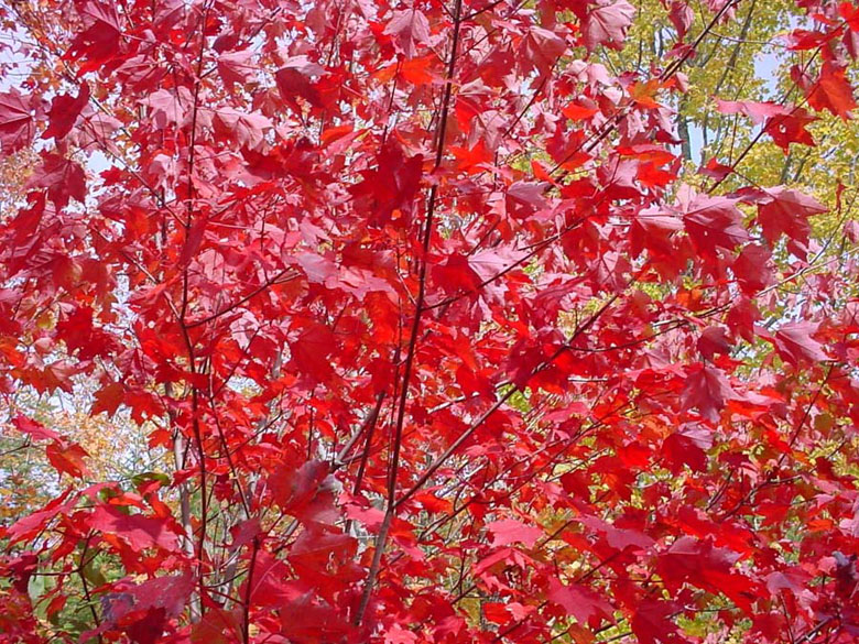
Depending on where you are in the U.P., fall colors are really starting to pop. There seems to be a lot of red this year. Below are a couple of shots taken of and near Taquanamon Falls. For those of you who have not been there, it is located an hour an a half east of Grand Marais.


History’s Gem of the Month: Pictured Rocks National Lakeshore Proposal Proposal Part 3

Summer 2008

(continued from the June & Summer 2008 update)

THE LAKESHORE PROPOSAL

As proposed, the national lakeshore would comprise an area about 35 miles long and 3 miles wide. It would contain approximately 67,000 acres, exclusive of any water area of Lake Superior. (The water boundary lies one-quarter mile offshore.)

The proposal is divided into two zones, with the use and management techniques of each zone differing according to its primary objective.

Land Use Plan

Objectives of the land use plan are to develop the proposed lakeshore for its optimum recreational potential and, at the same time and where possible, to utilize its renewable resources. A two-zone system is recommended to achieve these objectives.

Because the lakeshore zone is more richly endowed with scenic, scientific, and inspirational values than the inland buffer zone, it has the greater capacity to provide for public enjoyment. Consequently, its primary use will be for inspirational, educational and recreational purposes.

The inland buffer zone lacks dramatic features but is important for recreational development and stabilization and protection of the streams and watershed. It would, therefore, be managed for the fullest economic utilization of the renewable resources though sustained timber yield and other resource management practices compatible with the purposes of the national lakeshore.

Types f uses consistent with the objectives of the lakeshore include sightseeing, hiking, picnicking, camping, boating, canoeing, tobogganing, cross-country skiing, hunting, and fishing. Facilities to serve these activities would be placed at strategic locations, and would include information centers, contact stations, campgrounds, picnic sites, roads, hiking trails, boat docks, interpretive devices, campfire circles, and nature tails.

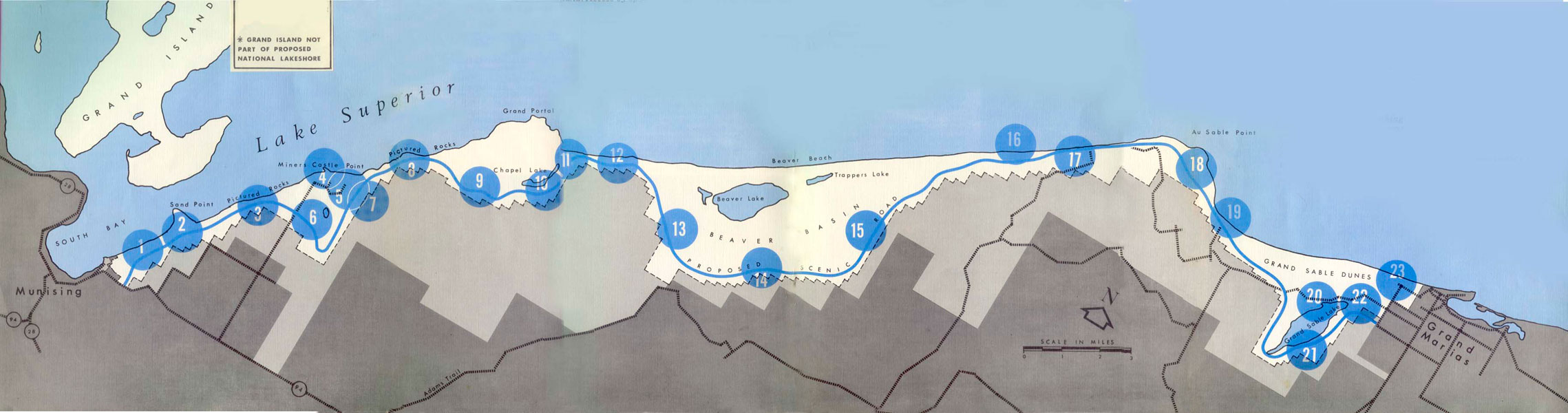
The Proposed Pictured Rocks National Lakeshore Map

The proposed development of the lakeshore includes 23 key locations. [Note: The actual development of the lakeshore varies significantly from what was originally proposed. The changes where present are noted below.]

  1. VISITOR CENTER: Information, interpretive exhibits, trail terminal, view of Grand Island. [Note: this center was constructed at Munising Falls, which does not have a view of Grand Island.]
  2. SAND POINT OVERLOOK: Parking area, interpretation station, nature trail, view of Grand Island, South Bay and Sand Point.
  3. PICTURED ROCKS OVERLOOK: Parking area, interpretation station, view of Pictured Rocks and Grand Island. [Note: This overlook was not constructed. Instead, a cross-country ski trail was installed.]
  4. MINERS CASTLE POINT: Picnic area, parking, sanitary facility, interpretation station, view of Miners Castle, Miners Beach, Pictured Rocks and Grand Island. Access by spur road.
  5. MINERS BASIN CAMPGROUND: Camping units, sanitary facilities, access by Miners Castle Point spur road. [Note: A campground was not installed at this location.]
  6. MINERS FALLS: Parking area, interpretation station, trail to falls.
  7. MINERS BASIN OVERLOOK: Parking area, interpretation station, view of Miners Basin, Miners Beach, Miners Castle and Grand Island. [Note: This development was not implemented.]
  8. PAINTED COVES OVERLOOK: Parking area, interpretation station, view of Painted Coves, Mosquito Harbor, Indian Head, Miners Castle, Miners Beach, and Grand Island. [Note: This development was not implemented.]
  9. MOSQUITO FALLS: Parking area, interpretation station, trail to falls. [Note: This parking area was merged with Number 8.]
  10. CHAPEL FALLS AND LAKE: Parking, interpretation station, view of Chapel Falls and Chapel Lake. [Note: A parking area was constructed, but it was moved well back away from the lake and falls.]
  11. CHAPEL BASIN OVERLOOK: Parking, interpretation station, trail to Chapel Rock, loop trail along Grand Portal, view of Chapel Basin, chapel beach and Little Chapel Lake. [Note: This development was not implemented.]
  12. SPRAY FALLS OVERLOOK: Parking, interpretation station, trail to falls, view of Grand Portal. [Note: This development was not implemented.]
  13. WEST BEAVER BASIN OVERLOOK: Parking, interpretation station, view of Beaver Lake, Little Beaver Lake, Trappers Lake and western portion of beaver basin. Access by spur road. [Note: Instead a campground and interpretive trail were installed at this location..]
  14. MID BEAVER BASIN OVERLOOK: Parking area, interpretation station, view of central portion of Beaver Basin, Beaver Lake, sandstone mesa and upper Seven Mile Creek. [Note: This development was not implemented.]
  15. EAST BEAVER BASIN OVERLOOK: Parking, interpretation station, view of eastern part of Beaver Basin, Seven Mile Creek, Seven Mile Lake, Hyde Lakes and the sandstone mesa. Access by spur road. [Note: This development was not implemented.]
  16. PINE BLUFF BEACH CAMPGROUND: Camping units, sanitary facilities, beachcombing, sunbathing, hiking. [Note: A primitive rustic campground was installed at Pine Bluff, as well as at several other locations along the lakeshore that were not included in the original proposal.]
  17. PINE BLUFF BEACH OVERLOOK: Parking area, interpretation station, nature trail, picnic area, sanitary facilities, view of Pine Bluff Beach. [Note: This development was not implemented.]
  18. AU SABLE POINT OVERLOOK: Parking area, interpretation station, view of Au Sable Point, conifer forest, bogs, ridge and swale landscape. [Note: This development was not implemented. However, drive-in rustic campgrounds were installed at 12-Mile Beach and the Hurricane River. An interpretive trail was also installed at 12-Mile Beach and the Au Sable Lighthouse has and is continuing to be developed to return it to the 1910 era. ]
  19. LOG SLIDE OVERLOOK: Parking area, interpretation station, access to dunes, view of Au Sable Point, Au Sable Lighthouse, Grand Sable Banks, and Grand Sable Dunes.
  20. GRAND SABLE LAKE CAMPGROUND: Camping units, sanitary facilities, nature tail, campfire circle, access to Grand Sable Lake with boat launch, swimming, water skiing, boating, canoeing, and bathhouses. [Note: Although the campground was never implemented, there are picnic areas, access to the dunes, and a boat ramp. Recently, a primitive one-unit camp site was constructed on Sable Lake that is accessible only by boat.]
  21. GRAND SABLE LAKE OVERLOOK PARKING AREA: Interpretation station, view of Grand Sable Lake. [Note: Although no interpretive center was constructed, a day-use picnic area was installed.]
  22. GRAND SABLE CONTACT STATION: Information, interpretive exhibits, trail terminal, picnic area, access to beach and dunes. [Note: Although a picnic area was not installed, a cross-country ski trail was implemented.]
  23. GRAND SABLE FALLS: Parking area, interpretation station, trail to Grand Sable Falls. [Note: The cross-country ski trail connects the Falls to the Grand Sable Visitors Center #22. Also, a Sanitary Station was also constructed.]

ROCKHOUNDING AND ADVENTURE TRIPS: Menasha, WI – Summer 2008

 Wonderful World of Agates, Weis Earth Science Museum, University of Wisconsin-Fox Valley, Menasha, WI July 10-13, 2008

A dedicated group of people have been planning this agate show for a couple of years. The purpose of the event was to celebrate agates and other forms of microcrystaline quartz. Everyone who attended agrees that they were completely successful. There were presenters and dealers from all over the world including Australia, Germany, China, Argentina, Brazil, India, and Mexico. Many of our states were also represented including South Dakota, Michigan, Wisconsin, Colorado, Texas, Montana, Nebraska, California, Virginia, Kentucky, Iowa, Washington, Oregon, New Mexico, Idaho, Tennessee, Missouri, Wyoming, and Minnesota. Below are pictures of the ribbon cutting ceremony to open the exhibits, as well as a picture of the main exhibit area and the agatelady.com booth, which was in the rear corner to the right under the American flag.

On Thursday at the show, a lifetime achievement award was granted to the First Lady of American Rockhounding: June Culp Zeitner. She has inspired rockhounds for more than 50 years. Mrs. Zeitner authored ten books and many thousands of articles, columns, and book reviews. Her first book, Midwest Gem Trails, helped to launch the rockhounding industry in the 1950s. In the 1960s she initiated the campaign that later led to all 50 states adopting an official state gemstone. In 1967, June founded the National Rock hound and Lapidary Hall of Fame, located in Murdo, South Dakota to recognize excellence in the earth sciences by inducting one or more persons each year. Below is a picture of June receiving her achievement award. When the booths opened to those who registered for the presentations on Thursday night, the first person who purchased something from my booth was June — which was a real privilege.

The presentations in the technical portion of the show on Thursday were outstanding. There were photos and information presented about agates from all over the world. Each presentation was 25 minutes long, allowing questions for five minutes from the registrants. I asked one of the presenters if he thought anyone would ever succeed in manufacturing artificial agates and was relieved when the answer was: “No, not likely due to the complex nature of agate genesis.” Below are a few of the pictures I took of agate close-up slides, that I believe were presented by Doug Moore.

In addition to the presentations and dealer booths, there were also agate displays. Below are some pictures of a few of the agates and microcrystaline quartz specimens. The Fairburn Agate is quite large: over 50 pounds! The Pseudomorphic agate is from Chihuahua, Mexico. It formed when agate coated and replaced aragonite. The Tennessee Paint Rock is an interesting mixture of agate, jasper, and chert. The Royal Imperial Jasper is from Zacatacas, Mexico. The Intarsia creations were magnificent and one of the hits of the displays. They were created by Eugene Mueller and are from the collection of Karen and David DeBruin. Each intarsia is a stack of very thin sections of various minerals sandwiched together to create the painting-like images.

Wonderful World of Agates, Weis Earth Science Museum, University of Wisconsin-Fox Valley, Menasha, WI July 10-13, 2008


Moose Lake Agate Days, Moose Lake, MN July 19-20, 2008

The 39th annual Moose Lake Agate Days was also a successful show. After trying to get into this show as an exhibitor for many years, my diligence finally paid off. For those of you who have attended Agate Days, you are aware that the rough rock displays are outside and other displays are inside the school. Thunderstorms hit the area on Saturday afternoon, all but shutting down the outside booths. Thus, all of the attendees crowded into the gym. It was nuts. I am sure the fire marshal was no where to be found.

For the first time I also attended the informal gathering in the motel parking lot on Friday night. Pictured below is an interesting Lake Superior Copper Agate purchased by Terry Roses. There were more large Lakers than you can even imagine. A few are pictured below.

As usual, I attended the show with my agate friends, Jill and Gerald Phillips. While in Minnesota, we visited with a friend who does not want to be identified. He acquired this 14 pound “bean” agate, shown by Jill below. Although there is no evident banding on the outside, it is clearly a large laker. When asked if he was thinking about cutting off an end to show the inside, he said: “Absolutely not. I want there always to be a mystery about what is on the inside.”


History’s Gem of the Month: Pictured Rocks National Lakeshore Proposal Proposal Part 2

Summer 2008

(continued from the June 2008 update)

Plant Life

Forests of Michigan’s Upper Peninsula are a transition between northern hardwoods and northern conifers. In some locations the primary stands are deciduous trees with an occasional mixture of pine and hemlock; elsewhere the steeple-topped spruce and fir predominate.

In the northern hardwood-conifer type forests, extensive stands may be almost pure maple but usually some beech, ash, basswood, paper or yellow birch are intermixed. The conifers, when present are generally white pine and hemlock although red pine, white and black spruce, balsam fir, and northern white cedar occur in some locations.

The conifer, or boreal type forest is not extensive in the Pictured Rocks region. Where the dominant conifers do stand, with their associated white birch, quaking aspen and mountain ash, the visitor can savor the essence of the north woods.

Other interesting types of tree communities include the coniferous swamps (containing the black spruce, fir, tamarack and white cedar) and, on drier sandy soils, stands of red or jack pines with an under story of bracken ferns.

Along with the trees are many interesting smaller plants. In the spring the yellow violets, squirrel corn, Dutchman’s-breeches, orchids, trilliums and pitcher plants add their beauty. When fall arrives the blueberries join the maple, beech, aspen, and other trees in an array of color.

Animal Life

Michigan’s Upper Peninsula is well known for its variety of animal life. The large number of whitetail deer present is indicated by a definite browse line within the area. Bear range throughout the area and wolf may occur. Otter, coyote, fox, bobcat, porcupine, beaver, and snowshoe hare are typical large mammals.

Northwood birds are well represented. The goshawk, bald eagle, ruffed grouse, three-towed woodpecker, gray jay, raven, hermit thrush, golden crowned kinglet, the northern warblers and the crossbills inhabit the proposed lakeshore. Loons and black ducks are seen on the larger inland lakes.

A combination of cool climate and pure water of the streams and lakes provide an excellent habitat for fish. Brook trout are in the streams. In the spring, steelhead trout from Lake Superior enter the streams to spawn. Larger lakes contain spiny-rayed fish and members of the pike family.

Climate

The climate of Pictured Rocks region is common to the northern Great Lakes — severe winters and warm summers. Marine influence of Lake Superior, however, has a moderating effect on temperatures: winters are milder and summers cooler than locations farther inland from the lake. The average daily high in the Pictured Rocks region during July is 78 degrees, the low is 53 degrees; in January the average daily high is 27 degrees; the low is 12 degrees.

Precipitation is rather evenly distributed throughout the year, with a slight increase during the warmer months. The area averages about 31 inches of precipitation annually, including nearly 100 inches of snowfall. In Michigan this amount of snowfall is exceeded only the 160 inches in the mountain range along the northwestern edge of the Upper Peninsula.

MINERAL OF THE MONTH: Summer 2008 Marra Mamba Tiger’s Eye

The mineral of the month for the summer 2008 update is Marra Mamba Tiger’s Eye. This mineral is found in western Australia, near Mount Brockman, but is thought to have been mined out over a decade ago. It forms when silica quartz replaces crocidolite (asbestiform riebeckite). Marra Mamba tiger’s Eye is known for its quality because it also contains red jasper, yellow chert, and black magnetite. I call it the psychology rock because people see different images in its chatoyant patterns. The fibrous nature of its parallel banded structure causes light to reflect through the layers, that roughly resembles the eyes of tigers or hawks. When there is enough magnetite in a specimen, it can be magnetic.

Other locations for tiger’s eye include South Africa, India, Myanmar, Sri Lanka, China, Brazil, Namibia, and California.

Tiger’s Eye is the planetary stone for Gemini (May 21 – June 20), and the celebratory gem stone for the ninth wedding anniversary.

It is thought by some to help with health and spiritual well being. Others believe that it is a psychic protector, aids in business, and helps one to achieve clarity.