CUSTOMER AGATE FINDS: December 2008

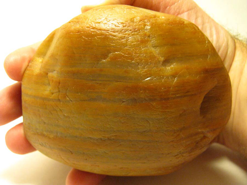
A couple of weeks ago I received a series of photos attached to an email from Todd Bird. When he purchased a house in Tawas, MI, this rock was left behind as a door stop. It is approximately 7.5” by 4” and weighs 5 pounds. Most of the specimen is translucent. There is banding throughout, with the most striking being the candy-stripped bands at the end of the specimen. I have examined it by zooming in with Photoshop. The bands definitely look self-organized, although the appearance is much different than that of other agates found in the upper Midwest. It most likely is some type of bizarre tube agate, probably formed within a sedimentary rock seam. The banding pattern reminds me of the sedimentary agate from Thunder Bay, Ontario, but the color and appearance is much different.

If any of you have seen something similar, or if you have any other ideas about the rock’s genesis, please send me an email to .

History’s Gem of the Month: Agate Leaflet from 1927

December 2008


While conducting research last week at U of M’s library in Ann Arbor, I was very excited about all the agate genesis articles I was able to locate. I concentrated mostly on articles published in the last decade. However, I could not resist the temptation to print off a 66-page leaflet published by the Field Museum of Natural History in Chicago in 1927. The leaflet was written by Oliver C. Farrington, the Curator of Geology and is entitled: “Agate Physical Properties and Origin.” It is amazing that in the last 80 years, our knowledge of agates has not changed very much. Below are some excerpts from the leaflet.

“Agate is a variety of chalcedony chiefly distinguished by its banded or variegated structure and coloring. Its banded appearance is due to the fact that it is made up of a great number of exceedingly thin layers which appear as bands in cross section. As seen by the naked eye, these bands differ considerably in width, some seeming no wider than a line, while others may be a quarter to a half-inch wide. In reality, all these bands are made up of still finer ones, the individuals of which can be seen only with a microscope. In a section of agate only one inch in thickness, Sir David Brewster counted 17,000 such individual bands.”…

…“The most common and characteristic form of agates is one which in cross-section resembles an old-time bastion, a defensive work characterized by curving contours and salient angles. Agates of this pattern are known as “fortification: agates (Plate 1).” …

…”Agates are generally formed in cavities in volcanic rocks. In the escape of gases and vapors from such rocks on cooling, cavities similar to those seen when pasty substances are heated are often formed and remain open when the rock has cooled. The cavities are usually spheroidal in form or, more specifically, are often shaped like an almond, whence the term amygdaloidal, from the Greek word for almond, is applied to them. The size of these cavities is also often about that of the almond but they may be much lager. It is in cavities like these that agates are chiefly formed, occurring as a filling that takes the shape of the cavity. Being of very tough material, which resists both physical and chemical corrosion, the agate nodules (the lumps or masses formed by the filing of the cavities) are usually left intact after the rock about them has decomposed and hence agates are often found in soil or in beds of streams. In the latter case, they may occur far removed from the place of their origin. The size of the agate nodules varies according to the size of the cavity in which they are formed. From very minute, they run up to weights as high as 4,000 pounds.”…

…”No one who gives much consideration to the subject of agates, can fail to be impressed with the difficulty of explaining how they are formed. They appear to be made up of successive layers deposited on the walls of the interiors of cavities, each layer toward the interior being younger than the one preceding. Sometimes the process of deposition appears to have continued until the cavity was entirely filled, but in other cases, a vacancy still remains at the center. If the above is the method of formation, it is difficult to understand why the deposition of the first layer, or, at least of the first two or three layers, would not close the cavity to succeeding deposits.

Various attempts have been made to answer this question. Haldinger, a German geologist, writing about 1849, made the suggestion that the moisture ordinarily found in rocks, the so-called “mountain moisture” would “sweat” through into the cavities and that successive solutions of silica would thus enter through diffusion. This explanation seemed adequate to many investigators, but others have agreed with Noeggerath, a contemporary of Haidinger, that it is doubtful if solutions would continually enter the cavity in this manner, especially as the outer layers of agate nodules are known by agate cutters to be particularly hard and impervious to liquids. As a better explanation Noeggerath called attention to an apparent canal or conduit which can be seen leading outwards from the interior of most agates and which he believed remained open during the formation of the agate for the admission of percolating waters. … In some agates, several such so-called entrance canals are to be seen, but in some unfortunately for the theory, none can be found. Moreover, it is difficult to understand why such canals, if they ever existed, would remain open. The above theories, however, are the only ones that until recently have seemed at all worthy of credence as possible explanations of the manner of formation of agates and for many years were accepted by most investigators.”…

…”It is only recently that a theory for the formation of agates has been proposed which gives a totally different explanation from the above and which is in many respects more satisfactory than the earlier views. According to the latter theory, the rock cavity in which the agate is formed, first becomes more or less filled with silica in a colloidal (jelly-like) condition. In such a colloid a banded structure can be produced by processes, which can be illustrated with ordinary gelatin.

The following experiment as described by Ostwald in 1896 illustrates this process. If silver nitrate is introduced into a colloid which contains ammonium bi-chromate, silver chromate (a red salt) is at once formed, but it does not at first appear in a solid form. It is still dissolved. Gradually, however, through the continual formation of silver chromate, the solution becomes so concentrated that it must somewhere separate out. This separation takes place first at an edge. Then all the super-saturated substance makes its way to this edge and likewise separates out. An essential consequence of this is that adjacent to this deposit, a zone is formed which is free from silver chromate. But this zone also does not contain ammonium bi-chromate, for this has been used up by the silver nitrate. Here, then, no new silver chromate can form and the zone becomes colorless. The excess of silver nitrate pushes on, however, and by the same reactions forms a second band of silver chromate and a color-less zone. Continuation of this process gives a banded structure.”…

…”Besides explaining the banding, this view of the method of formation of agates also indicates why agate nodules are often hollow in the interior. Drying of the colloidal silica causes a shrinking in bulk which would often leave such a hollow. The theory also explains the frequent occurrence of quartz crystals in the interior of agates. Crystals cannot form in colloids on account of surface tension, but when the tension is relieved at the hollow interior of the nodule, complete crystallization can take place there.” …

…”According to the present view, then, fortification or common agates originate from a filling of hollow spaces in rocks by a silica colloid (jelly), within which an iron salt compound has been rhythmically deposited.”

MINERAL OF THE MONTH: December 2008 Picture Jasper


Jasper is a form of microcrystaline quartz. Its name comes from the Greek word, iaspis, which means “Spotted Stone.” Jasper comes in many colors and patterns, but is most often red, brown, or green. Jasper is what I refer to as a “First Cousin” to agate. Both semiprecious stones are microcrystaline quartz. The difference between them is the size and shape of the quartz microcrystals. Those in jasper are small, round grains of quartz crystal, which pack together tightly like bee-bees in a jar. Thus, jasper is usually opaque. Agate, on the other hand, has slightly larger fibrous quartz crystals, which results in it being translucent in most cases.

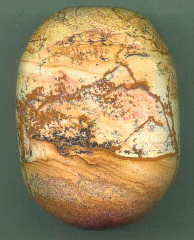
Many jaspers are actually metamorphic rocks. In cases like Picture Jasper, the colorful patterns result from other minerals that are present in the specimen. Picture Jasper primarily comes from Idaho and Oregon. It formed when mud rich with quartz oozed and dripped into pockets of gas formed by molten lava. The heat from the exposure turned the mud solid almost instantly. Therefore, Picture Jasper is actually petrified or silicified mud. Because of its interesting patterns, it has been used as a psychological tool: the researcher will ask a client who is “looking for an answer” to gaze into the stone and describe all the symbols he sees. The researcher then works with the client to form the symbols into some sort of answer. Picture jasper is said to help with the re-evaluation of life’s issues. It is also believed to facilitate development and continuance of business pursuits and activities. It can also be used in meditation to encourage balance, as well as to help you to improve your self confidence and courage.

CURRENT GRAND MARAIS SCENES: December 2008

Winter has come early this year to many areas — including Grand Marais. Since my house sits up on a glacial hill, it is at the mercy of the wind all winter long. The wind piles the snow on the south side of the house. It usually takes all winter for the snow to pile 7 feet up to my kitchen window. Guess what? It is already there! The rain we had this week did not condense or melt the snow much. Plus we received another few inches today and have more forecast for every day this week. On the level, I have around two feet of snow in my yard — but there are drifts everywhere! It is a good thing that the snowplow company I hire for the season to keep my driveway open has a front-end loader!

The first two pictures I took just before Christmas. I cross-country skied and then took my skies off at the top of Sable Falls steps. It is always a challenge to descend the steps in the winter, but well worth the scenery. As many of you will recognize, these pictures were taken at the bottom of Sable Creek. The shots document the beginning formation of icebergs, looking both west and east.

The next two pictures show winter paths. The first was taken on the path next to Sable Falls. The second was taken on my ski trail path behind my house. While I was down state for Christmas, the snow piled up too much to ski. Thus, I was out snowshoeing this afternoon to pack down the snow so that I can ski tonight by headlamp.


CUSTOMER AGATE FINDS: November 2008

Agate hunting is soon to be done for the year. I haven’t had time to go out, but a few of my friends have been diehards and have found a few small agates as of late.

The agate finds featured this month include some found by Adam Nothelfer, who is from the Lapeer area of the Lower Peninsula. They are all very unusual, each for its own reason. First of all, there is the agate he found in on his family’s private property in a small lake in far northern Lapeer County, north of the town of North Branch. This lake was once a gravel pit and has produced masses of fossils, Petoskey Stones, and other minerals. This 1 pound 5.5 ounce agate is apparently the first agate to be found in the lake. According to Adam, the pictures DO NOT do this specimen justice. He says that “It is absolutely dreamy to get it wet and look at it under the magnifying glass. It has eyes all over it and areas of banding mostly white but some with red and pink floating in clear chalcedony.” The dimensions are 4.25″ x 3.5″ x 2.5″ — quite large for any agate. It certainly appears different than Lake Superior agates. If I were to guess, I would say that it is an agate that formed within a sedimentary rock pocket.

Apparently Adam usually comes to Grand Marais to agate hunt. This year, he instead headed to the Keweenaw Peninsula and looked for copper replacement agate nodules at the Wolverine Mine. Pictured below are a couple that he pulled out of the basalt piles wherein the agate nodules fractured in half while still in matrix. Adam collected a large plastic coffee can full of nodules and hopes that more have banded agates inside, and maybe, some — with copper bands.

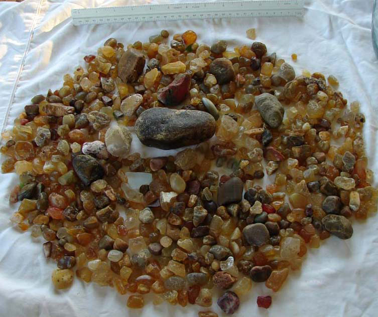
The last agate picture agate sent to me is one of a yellow and white water level banded agate. It looks similar to others I have seen that come from Vermillion Beach. However, he says that he found this 3.5 pounder near Muskellunge Lake, east of Grand Marais around 20 miles.

I have seen several of these, but have not had time to really study them. From what I can see in the emailed picture, it appears to have distinct water level bands that alternate between chert and chalcedony. It appears that this also was formed in a sedimentary rock pocket.

If any of you readers have anything to add about any or all of these unusual agates, please send me an email to .

MINERAL OF THE MONTH: November 2008 Prehnite

This yellow-green mineral is found throughout the world, but most notably in Australia, South Africa, Germany, and the United States. The specimen featured this month was found in the Keeweenaw Peninsula in Michigan’s Upper Peninsula. It not only includes crystals of Prehnite, but also specs of copper, calcite, and silver. It forms near the surface of basaltic lava flows and often occurs in geodes or veins. It forms as a result of low grade metamorphism from hydrothermal solutions.

Prehnite can be confused with gyrolite, smithsonite, and hemimorphite. It can be distinguished because it is harder than these other three minerals. Smithsonite has more of a vitreous or pearly luster and hemimorphite is usually bluer in color while gyrolite is not as glassy.

Prehnite is a phyllosilicate of calcium and aluminum with the formula: Ca2Al(AlSi3O10)(OH)2. It is brittle with an uneven fracture and a slight vitreous luster with a white streak. It has a hardness of 6 to 6.5, with an average specific gravity of 2.80-2.90. It is translucent with a color that varies from light green to grey, yellow, or white. When heated, this mineral gives up water but will not take the water back up when cooled.

Phrenite was first discovered in South Africa by Colonel Hendrik Von Prehn, an early Dutch governor of the Cape of Good Hope colony. It was the first mineral to be named after a person.

Its metaphysical properties are thought to enhance energy, provide protection, and promote calmness. It is also used to advance the state of meditation and help you to remember your dreams.

CURRENT GRAND MARAIS SCENES: November 2008

Fall is an unbelievable time in the Upper Peninsula. The temperatures this past month or so have varied from 75 to 20 degrees. The winter season has begun, though, with a snow storm that dropped over 20 inches in some places. In Grand Marais proper, we received around 8 inches so far. As usual, the lake effect machine dropped most of its load south of town.

All of the pictures featured this month were taken before the snow. There will be plenty of time in the next few months to document the winter scenery.

The first few pictures were taken on a couple of trips I took to the Keewenaw and Minnesota to go agate hunting. Those of you who come to Grand Marais to enjoy our beaches are somewhat spoiled. Although I like all of Lake Superior’s beaches, there are not many that offer the wide expanses of sand, rocks, and driftwood as is true in the Grand Marais area.

Included are a couple of shots of beaches elsewhere. The first was taken on Presque Isle in Marquette. I absolutely love the lava rock and enjoy imagining what it would have been like to see the molten flows inching toward Lake Superior. The second shot was taken on the north shore around 20 miles north of Duluth. You can see that both of these areas essentially have no sand at the shoreline.

Gooseberry Falls

While on the north shore, I spent a little time hiking at Gooseberry Falls. What a rugged and beautiful landscape this Minnesota state park offers.

Before the snow started, I took a few last hikes in the dunes. The first shot was taken on the path that skirts the base of the dunes on the Masse Homestead path. This path is located half way between Sable Lake and the Log Slide where the little pull out/parking area is on H58 west. I love the way that the yellows play in this photo between the ferns and the trees. From this path, there are a couple of places you can access the dunes. I did so and walked across to the lake. I’ve included a picture of one of the gravel beds on top of the bluff. It was from one of these gravel beds that the museum founder’s 5.5 pound agate tumbled down the Grand Sable Banks for Axel to find in 1958.


CUSTOMER AGATE FINDS: October 2008


Although I think spring is the best time to agate hunt given that the recently melted icebergs dump their load of new rocks on the beach, there have been a lot of good finds this fall. I do agree that the fall storm waves mix the rocks and sometimes push new rocks up onto the beach. Other times, though, the waves will undertow the rocks out back into the lake and/or cover them up with sand.

None the less, there are several recent finds featured this month. My friend, Renee Beaver who appeared last month, is featured again with a 1/3 pound candy stripper.

The Weihing family contacted me early this fall about their successful agate hunting trip to Minnesota. Ashley, Kayla, and Courtney show off their finds in the pictures below.

Ron and America Dukowitz emailed me the picture below documenting their recent U.P. agate finds.

And finally, I recently took a few days off to agate hunt in Minnesota with my friend, Tom Tomasek. Pictured below is Tom and his dog Alex, as well as the agates he found on the trip.


History’s Gem of the Month: Pictured Rocks National Lakeshore Proposal Part 5

November 2008

Probable Economic Impact of the Lakeshore

The most direct economic impact of the proposed lakeshore will be upon the forestry and recreation industries of the Upper Peninsula region. These industries and associated economic opportunities are examined here.

Forestry

Forest industries are the largest single source of employment in the Upper Peninsula region. In 1960, thee were an estimated 9,900 engaged in logging, and 8,300 in forest product manufacturing, making a total of 18,200 full-time equivalent workers. This was about 18 percent of the total workforce of approximately 100,000. The gross income of the Upper Peninsula forest industry was estimated at $109 million in 1960.

The area around the proposed lakeshore is even more dependent upon logging and forest manufacturing operations than is the Upper Peninsula generally. Mills now drawing partially upon raw material from the “recreation zone” employ 190 full-time and 66 part-time workers. Their payroll is reported at $875,000. There are, in addition, many mills and plants drawing raw material from the general vicinity. Although not currently using pulpwood from the Upper Peninsula, the Kimberly-Clark Paper Mill at Munising employs 500 to 600 workers. Within a radius of 70 miles of the proposed lakeshore, there are 400 to 500 men employed in the woods with annual payrolls in excess of $1,000,000.

Because of regeneration of forest stands in the Upper Peninsula region, new wood processing plant development, there is now taking place and is expected to continue. The proposed Pictured Rocks National Lakeshore is not expected to have a substantial influence on the possible location of new wood-using plants in the region, or on the operation of large plants that are there now. There will be, however, increased economic pressure on small mills operating in the immediate vicinity, if timber harvest is suspended in the “recreation zone.”

Tourism

Two recent estimates of 1960 tourist expenditures in the Upper Peninsula average to $110 million. Other studies have shown 25 to 27 percent of tourist expenditures becoming direct personal income. On this basis, the direct incomes to operators and employees from tourism in 1960 were $27,500,000. In terms of $5,000 jobs this is an employment of 5,500 full-time equivalents, although, like forestry, it is probable that several times as many individuals had at least part-time employment. Thus, tourism in the Upper Peninsula is a major source of employment. Rapidly increasing national demand suggests that tourism could be a still larger economic contributor to the region.

Alger County tourist expenditures have been as high as $2.9 million in 1957 but dropped to $1.3 million by 1961. The drop was part of a stagnation or decline across the entire region. This decline is confirmed not only by year to year estimates of total expenditures but by traffic counts over the region, crossing at Mackinac Bridge and attendance at state parks.

The proposed Pictured Rocks Lakeshore would be expected to make its major contribution to Upper Peninsula tourism by helping to strengthen the “image” of this “north woods and lakes country” as a tourist destination area. The lakeshore would add a major destination point at which recreation services – things to see and do — would be available. As a part of the National Park System, it would give national status to the Upper Peninsula. The lakeshore would be a significant addition to the complex of regional attractions: from Mackinac Bridge, Mackinac Island, Soo Locks and Tahquamenon Falls in the east; to the copper mines, ghost towns and Fort Wilkins of the Copper Country (northwest); the Porcupine Mountains State Park in the west; plus a wide variety of resorts and private recreation developments throughout the region. Finally, the positive action of developing the proposed lakeshore could be expected to help spark constructive developments by private firms in the tourism industry.

Estimates of the gross income and employment due to the proposed lakeshore vary depending upon the future character of the Upper Peninsula’s tourism industry. If the industry retains its present relatively passive nature, added gross income to the region might be only $2,967,000 ten years from the present, generating an additional 167 full-time job-equivalents earning an average of $5,000 per year. On the other hand, if a more aggressive tourism industry develops, the added income and employment due to the proposed lakeshore could be more than twice the above projections, or $6,242,700 and 365 jobs, respectively. Both of these projections include an estimated $166,700 spent for 27 full-time job-equivalents for operating and maintaining the proposed lakeshore. These projections extend ten years into the future.

The lower of the two estimates is based upon an estimate of 500,000 annual visitors to the lakeshore, should it have been in full operation in 1962. Since the actual projection is for ten years later, the 500,000 is increased by 50 percent to 750,000 as an estimate of growth that may occur in a decade. There are a number of good indices for such estimates: (1) Crossings of the St. Mary’s River at Sault Ste. Marie increased by 160,000 between 1960 and 1961 when the Canadian North Shore Route was opened; (2) The Cape Hatteras National Seashore had an attendance of 649,000 in 1962. (3) Attendance at the Porcupine Mountains State Park is approximately 200,000 (it has only one overlook). (4) A number of specific attractions in the Upper Peninsula have had rapid growth in visitation despite recent stagnation in the general tourism industry of the region. (5) Elements of the National Park System that are resource-based have been experiencing an annual increase in the use of 9 to 12 percent, thus, a 50 percent increase in ten years appears reasonable in a passive setting.

Taxation

Removal of all privately owned land in the “recreation zone” from tax rolls would reduce the combined incomes to Munising Township, Munising City, and Burt Township by about $12,400. This is made of property tax revenues plus a $771 payment from the State of Michigan in lieu of taxes on state-owned lands.

A partial immediate compensation for this tax income reduction will result from park development work. Preliminary plans program an expenditure of $5,826,950 for this purpose over a four-year period. If even the lowest estimate of added employment due to the lakeshore is realized, personal property taxes of employees alone would account for more than tax losses. Property value improvement due to expanded business should add even more tax revenues.

NOTE: In 1962 there were only 164 structures in the proposed lakeshore. While buildings are distributed throughout the area, most intensive developments are on Miners Beach, Grand Sable Lake, and in and near Munising City.

Economic Opportunities

Implementation of the proposed lakeshore would expand economic opportunities for private entrepreneurs. This increase will be in the tourism industry. Firms and individuals with land holdings in the vicinity may have especially favorable opportunities for business profit.

Forest industries will suffer a reduction in the form of fewer job opportunities in logging operations and accelerated pressures that have already caused the closing of many smaller mills. This loss will be offset by increases in tourist revenue and related job opportunities. Most of the firms owning large tracts of land for forestry purposes that are in the “recreation zone,” also have other holdings outside the proposed lakeshore. They are, thus, in one of the better positions to take advantage of new business opportunities that would develop; they have access to land, to financing and to top-level management — all of these are ingredients badly needed by the region’s tourism industry.

General Conclusions

Evidence of this study suggests a definite advantage to the economy of Alger County and the Upper Peninsula in the establishment of the proposed Pictured Rocks National Lakeshore. This advantage would come through improved opportunities in the tourism industry. Local logging and milling operations would be curtailed but this loss would be much more than offset. In addition, it is expected that no important reduction in the region’s ability to attract wood processing industries would occur.

MINERAL OF THE MONTH: October 2008 Mexican Opal

Mexican Opal comes from the Magdalena, Jalisco area of Mexico. Historians have determined that the Aztec people used Mexican opal for ceremonial and ornamental purposes between 1200 and the early 1500s when the Spaniards Conquistadors took over the area. It is known by locals as vitzitziltecpal or the “humming bird stone” due to the iridescent similarity to the feathers of the bird. It also has several other local names including fire opal, jelly opal, crystal opal, cherry opal, and girasol. Many ancients believed that the storm god became jealous of the beauty of the rainbow god. As a result, the storm god broke the rainbow, causing pieces of the rainbow to fall to the Earth to become a part of the opal which exhibits the “rainbow-fire” appearance.

After the Spanish took over the area, the source of these opals was lost until 1840 when Sir Jose Maria Siurab discovered the deposits. Mining still continues today, but the number of opals found has dwindled since the peak production in the late 1960s.

All opals are hydrated silicates containing between 3 and 10 percent water. Some, but not all opals, have a “play of color.” This color show results from diffraction and interference of light rays that travel through the spaces between columns of microcrystaline spheres of silica. The diameter of the spheres within any column determines the resultant color. If there is no color, as is true with common opal, there is a random pattern of microcrystaline spheres, and thus, no structure to act as a diffraction grating.

The specimen featured this month was purchased from a small rock shop located just outside of Yosemite National Park during the late 1990s. I had just finished hiking with my friend, Clare Comstock, when she spotted the rock shop. This six pound gem was on display as an example of opal from a Mexican mine operated by the rock shop’s owner. When I saw the specimen, I asked about its availability for purchase. Although the owner said it was not for sale, she finally agreed to part with it as long as I agreed to display it prominently in the museum. Not only have I done that, but now I’m featuring it as the Mineral of the Month.

I have left this specimen raw because of its innate beauty. Plus, opal can be somewhat fragile and has a tendency to develop fine cracks due to dehydration. I only “dress up” and polish rocks if it will increase the value of the specimen. For this beauty, it is not worth the risk.

Gemological Data

Chemistry: hydrated silicon dioxide
Luster: vitreous to resinous
Hardness: 5.5 – 6
Crystal structure: none, it is amorphous
Fracture: conchoidal to uneven
Cleavage: none
Density: 2.15
RI: 1.42 – 1.43
Birefringence: none

Metaphysical Properties

Opal helps with the amplification of your most positive traits, therefore, providing the ability to overcome your lesser attributes. It can also improve your creative flow and maximize your inspiration and imagination. Opal has been used by the Native American Indians and the Australian aboriginal shaman to invoke visions and to facilitate ceremonial “dreamtime.”