ROCKHOUNDING AND ADVENTURE TRIPS: New Mexico – February 2009

It has been three years since I drove out west to attend the Tucson Gem and Mineral Show. Of course, in 2005 and 2006 I lived in New Mexico all winter and sold my mineral art as a member of a co-op gallery. Thus, during these years the drive to Tucson was a lot shorter! Last year was the first time in a decade that I did not attend. This year since I have the new vehicle, I decided to drive. However, since I was driving out without staying for a few months, the driving was consolidated into a three week period. As a result, the total miles of 6,060 represented an average per day of over 275 miles! Considering that I spent five days in the Tucson area, three days in New Mexico, and four days at the Grand Canyon, it is obvious that there were several days that I drove over 800 miles – especially on the way home!

After visiting friends and relatives down state, I started driving south to Arkansas on February 2nd. Thanks to the books on tape loaned to me by my friend, Marsha, I drove to within an hour of Arkansas the first day. The next day I visited Garvan Gardens in Hot Springs, operated by the University of Arkansas. I needed a break to get some exercise. Although it was chilly, there were several trees in bloom. I am sure the blooms didn’t make it much longer since the temperature dropped to the mid-teens that night. During my travels, it was colder than I expected, but I stayed toasty sleeping in my Suburban on a roll-away mattress situated on a raised platform.

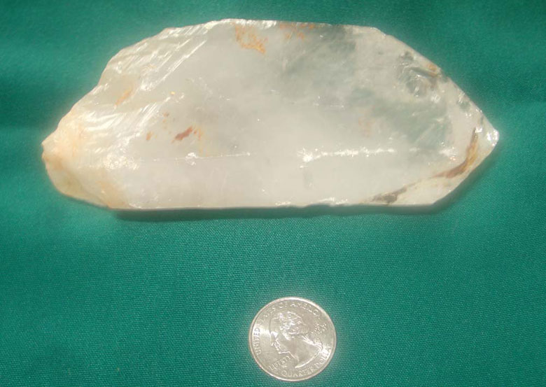
On Tuesday, I rendezvoused with Dee and Gee, who own one of the crystal mines located around 40 minutes from Hot Springs. They told me about a near-by campground that is free in the winter. We met up again the next morning and I followed Gee over to his mine. I enjoyed walking over his dump piles looking for evidence of any quartz crystals. I only stayed for a few hours, but found several dozen crystals, including the monster shown below – well worth the $20/day fee!
After continuing my drive to New Mexico, I spent the next few days visiting with friends, soaking in the hot springs at Ojo Caliente, and hiking at Bandelier National Monument. Pictured below are some of the pictures I took at the Tsankawi portion of Bandelier. This part of the national park has been left untouched by the National Park Service and remains the way it was when the cliff dwellers left over 500 years ago.

The driving continued on Monday as I arrived in Benson, AZ that night. The next morning, we were greeted with four inches of snow. Of course, everyone blamed me for bringing the snow from Michigan. I spent the rest of the week attending the Tucson Gem and Mineral Show, which are actually 44 different shows. I don’t think that anyone actually goes to all of them, but I visited at least a dozen. I not only purchased some of my standard products, but I have several new things for the museum’s gift shop. I also had the pleasure to buy higher-ticket items for friends in Lansing. It is a good thing that I have a bigger vehicle because I had to fit a lot of product into the car. I don’t think I could have done it if I didn’t have room under my bed’s raised platform.

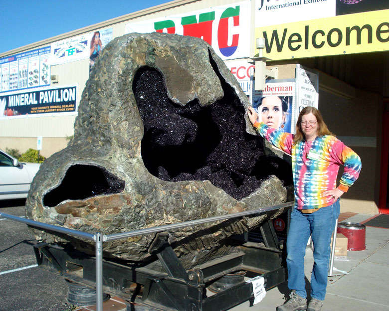
At one of the shows, to entice buyers to come in, they situated one of the most incredible amethyst geode that I’ve ever seen. How this was mined out of the earth and transported from Brazil to the J.O.G.S. show in Tucson – I’ll never know!
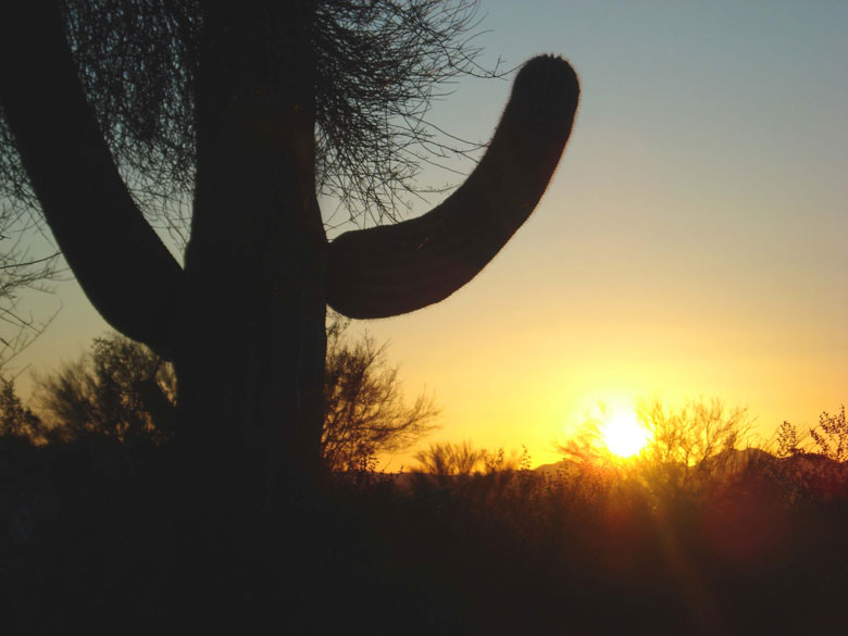
After I left the show, I camped at Tucson Mountain Park, which is located west of the city. Below is one of the cactus pictures that I took at sunset.
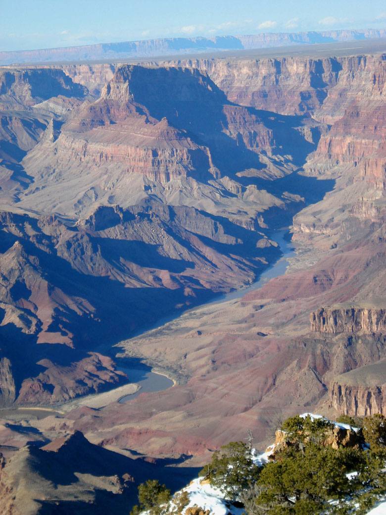
The next item on the agenda was the Grand Canyon. I drove through the eastern entrance of the park. The photo below was taken from the top of Desert View.
This was my 14th hike down the canyon, but only the second time that I hiked all the way from Phantom Ranch to the top in one day. I was glad that an opening occurred so that I could stay down an extra day to recover a little before I had to hike out. I descended down the South Kaibab Trail, which is the shortest rim to river trail at a little over 7 miles, but also the steepest. The first picture below was taken at the top of the Kaibab Trail.

As I walked down, since I was on a solo hike this time, it gave me the opportunity to read one of my Grand Canyon geology books as I descended layer by layer. Since the top section of the trail is in shadows all day, it is quite icy this time of year. Hiking poles and boot crampons are a must if you want to be safe. The trail starts with a long series of steep zigzags through the Kaibab Limestone. The tan walls are pitted with thousands of white and yellow chert nodules. These pockets formed from the silica spicules that accumulated from the sponges that lived in a shallow sea here 270 million years ago.

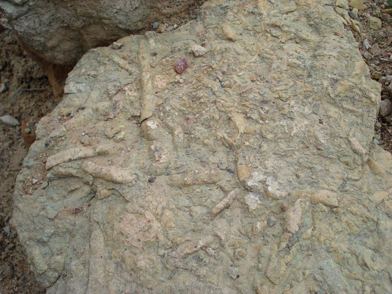
When I was around half way down and hiking through the Supai Group along the O’Neill Butte (formed 310 to 285 million years ago), I explored a flat area to the west of the trail. I was surprised to find some self-organized microcrystalline quartz pockets inside the sedimentary rock.

As you hike around the O’Neill Butte and past Skeleton Point, the trail descends down a massive cliff of red wall limestone that was deposited in a shallow sea that covered most of the North American continent more than 318 million years ago. After you finish with the switch backs, the trail straightens out as you pass outcrops of Mauv Limestone (350 to 400 million years old) that have ripple marks and worm burrows.
Next, after passing the rest area at mile 4.6, the trail reaches “The Tipoff,” when you enter the inner gorge. This is the first real good look you have of the Colorado River, which appears directly below you. On one hand you are relieved that you can see Bright Angel Campground and know that the end is in sight. Then you realize that you still have nearly 3 miles to go, including a good deal of the elevation change.

The last mile and a half of the trail seems to be a never ending series of switchbacks. I was entertained, though, by seeing my favorite Grand Canyon rock: Zoroaster Granite. This salmon-pink rock is comprised of pink orthoclase feldspar, white quartz, and shiny silver mica. Around 1.7 billion years ago, the area that is now the Grand Canyon was an ocean. The continental plate ended at what is now Wyoming. The ocean plate collided with the continental plate, and the ocean crust subducted down approximately 7 miles below the earth’s surface. Some of the rock heated and metamorphosed to form various schists and gneisses. Other rock subducted a little deeper and melted. As the magma rose back toward the surface in big blobs, similar to the wax blobs in a modern-day lava lamp, it squeezed its way into and around the metamorphic schists to cool into veins of pink granite. Below is a close-up picture of the granite, as well as a photo of the inner gorge wall showing the seams of granite inter-twined in the Vishnu Schist.

After leaving the top at around 8:30 a.m., I arrived at Phantom at 4:30 p.m. I stopped in the canteen to get my cabin assignment. Each of the dorm cabins have 5 bunk-bed cots, a toilet, and a separate shower. After a quick shower, I headed to the steak dinner, served family-style, at 5:00.

On the in-between day, I hiked to the top of the inner gorge on the north side, down the Cedar Creek Trail. This was a tremendous day. I found a south-facing ledge and parked myself for a few hours. I spent the time reading my geology books, taking pictures, eating my Phantom Ranch bag lunch, and taking a nap. As I sat there, I really studied the rocks and layers of the Grand Canyon. One of the surprising things I learned is that there are many gaps in the geologic record. One of the largest is the gap named by explorer, John Wesley Powell. He named the gap: The Great Unconformity. The amount of geologic record missing varies across the length of the canyon. In the picture below that I took from the Cedar Creek Trail, you can see that the horizontal Tarpeats Sandstone (525 million years old) sits directly on top of the 1.7 billion year old Vishnu Schist and Zoroaster Granite. Thus, 1.2 billion years, or one-quarter of the earth’s history, is missing! This gap is shown below in the left photo. The picture on the right was taken from the Cedar Creek Trail, looking down the inner gorge toward the east.

At Phantom Ranch, when you are preparing to hike out of the canyon, the day starts early when one of the employees knocks on your door at 5:00 a.m. Breakfast is at 5:30. I started hiking out by headlamp just after 6:00 a.m. I took the shot below with the self-timer, by placing my camera on the corner of the silver bridge.

Then, I hiked the 9.6 miles out the Bright Angel Trail getting to the top at 3:00 p.m. In total over the three days, I hiked nearly 23 miles with an elevation change of over 12,000 feet! Although I enjoyed it, I must admit that it does not get any easier, especially since I am now in my mid-50s! Below are a couple of the photos I took on the nine-hour hike out of the canyon. I sure was glad to get to the top!

I would like to thank all those who helped me and/or spent time with me along my travels including: Kim Amthor, Jonathan and Jessica Brzys, Marsha Hendrickson, Clare Comstock, Ardis and Ed Hannish, Karen and Harold Boaz, and Sandra and Mark Lange.
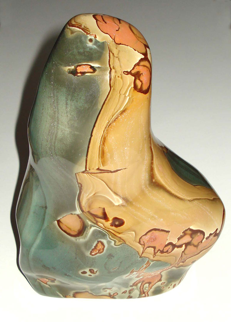
MINERAL OF THE MONTH: February 2009 Polychrome Jasper


A new, but very small deposit of Polychrome Jasper has recently been found in the deserts of Madagascar. Specimens from this deposit were first sold at the Denver Gem and Mineral Show last September. Since I was going to the Tucson Show, I was commissioned to purchase larger and unusual mineral art specimens from friends who live in Lansing, MI. This was an awesome responsibility, but I enjoyed searching for and negotiating the purchase of higher-end specimens. As soon as I saw the Polychrome Jasper, I knew I had to add this to the list.

Polychrome jasper is a type of opaque, multi-colored chalcedony which develops in massive formations. Unfortunately, the formations found in Madagascar are few in number. It also goes by the name of Royal Savannah Jasper and Desert Jasper. It is believed to be one of the rarest jaspers in the world. In addition to the new pockets found in Madagascar, some deposits are also located in Australia.

Like other chalcedony minerals, it is thought to be a protective stone that improves self assurance and confidence. It can also help to foster a positive attitude. Professional guitar players are familiar with the stone because Polychrome Jasper is used to make high-quality guitar picks.

History’s Gem of the Month: Snowstorm Article from 1988

February 2009

While searching through my archives, I came across this article published in the Detroit Free Press on Friday, February 12, 1988. Given that we have an old fashioned winter this year, I feel that it is appropriate to include the reprint this month.

Snowstorm

is kid stuff, UP folks say – Downstate troubles pale next to Yoopers’ tales
By David Hacker

Bad weather downstate, eh?

Listen you Loopers, take a cue from the yoopers when Mother Nature offers a midseason white sale the likes of Thursday’s storm.

Almost a foot of snow? Ten degrees and 30 m.p.h. winds?

Pffffffft. That’s nothing they say.

Bessie Capogrosa can see snow banks 10 feet high when she looks out the window of her Superior Hotel in Grand Marais on the north shore of the Upper Peninsula.

Jim Carter, a Grand Marais native and local historian, now news director at Northern Michigan University in Marquette, recalls “the huge blizzard of 1938, when (the snow was so high) you could walk up to the second-story porch of an old hotel. I’ve got a picture of my mother sitting on the crossbar of a power pole.”

“Ten inches of snow? I wouldn’t notice it,” said Celeste Bailey of Grand Marais.

A friend of Carter’s, Ed Erickson, played for Grand Marais High School in the district basketball tournament in Marquette in March 1928. Earlier that winter, Grand Marais had been marooned for a week by impassable snowdrifts. Two weeks before the team was to leave for Marquette, the town was sealed off again.

“The superintendent, George Butler, who also was the coach, and a half-dozen players snowshoed the 26 miles to Seney to catch the night train to Marquette”, Carter said. “They lost to Republic, 27-14.”

“In the late 1880s, Carter said, a Manistique Railway train got stuck in the snow for a week a few miles from Seney. The engineer spent the week snowshoeing back and forth into town to get food for passengers.

“We think of ourselves being tough guys up here, said John Vaara, principal of Hancock High School, where 29 inches of snow covered the ground Thursday. “We have had a real harsh winter. We hear about snow days elsewhere in the state where schools are missing many, many more days. We sent the kids home early two days but we haven’t had a snow day yet.”

Bill Nyman, who has driven an Alger County snowplow out of Grand Marais, said “Our average snowfall here is over 200 inches. One winter we had over 300 inches. A year or so after I went to work here 17 years ago … — I think it was the winter of ’72 – I’d come to work at 7 in the morning and stay until midnight. I would go home so tired I couldn’t sleep. Then I’d be plowing snow in my sleep and shoveling snow out of the end of my bed.”

History’s Gem of the Month: Hints on Hunting and Finding Agates – PART II

 Fall 2009

While I was looking for something to include for this month’s history gem, I ran across yet another article written by Axel, which is different than the one that I included last month. This one is a rough draft, and required editing.

Hints on Hunting and Finding Agates
By Axel Niemi and Karen Brzys

There are two outward appearances to a Lake Superior agate. Some have the unworn outer look, while others have a worn or broken and chipped look. Most Lake Superior agates have an almond shape, called amygdaloidal. This denotes that the agate formed inside vacated gas pockets inside what was originally molten lava. As the gas gets trapped in the molten lava, the lava continues flowing, elongating the gas pocket. As the lava continues to cool, the pockets also harden, after which the steam escapes. Silicon dioxide quartz, with impurities of other minerals, later fills the pocket. The quartz and other impurities form submicroscopic crystals to fill in the pocket.

The unworn agate with original outer husk is more difficult to recognize. However, these unworn agates are usually only found where they formed, and must be mined out of the basaltic lava material. Most Lake Superior agates that have eroded out of the basalt are gravel-worn and easier to spot and recognize. All chipped agate has a waxy surface texture, which can expose the translucent nature of the microcrystalline quartz as well as the banded structure. Thus, in most cases when you are agate hunting on the beach, agates are rare but when you find them, it is usually obvious that they are agate. If you are not sure if it is an agate, it probably is not.

Several different types of agate can be found on the Lake Superior beach, some of which include:

  • Candy Stripe Agate: An agate with alternating red and white bands.
  • Carnelian Agate: A translucent agate with red to brown-red color. Carnelian can also form without banding.
  • Eye or Orbicular Agate: An agate with a circular eye formation on the outside of the specimen.
  • Fortification Agate: Agates with concentric bands.
  • Moss Agate: These agates have mossy looking mineral inclusions.
  • Paintstone or Dryhead Agate: These agates are not translucent due to the larger amount of impurities that are contained within the specimen. Many have pink and tan colors.
  • Peeler Agate: When agates are exposed to the weather, some of the bands may erode at a different rate than others. The result is an agate wherein the bands seem to have peeled back, like the layers of an onion.
  • Ruin Agate: These agates form with the pattern is broken, and then re-cemented back together by additional agate formation.
  • Sagenite Agate: These agates have many fine crystals, elongated and fan shaped, usually as an inclusion inside an agate. The fine crystal “needles” are usually formed by the mineral rutile.
  • Shadow Agate: These agates have tight banding with alternating opaque and translucent layers. As light enters the agate, it bounces between the layers. When you move the agate back and forth, you can see what appears to be a shadow, racing across the surface.
  • Tube Agate: In some cases, agate replaces other tube-shaped minerals forming interesting elongated patterns.
  • Water Level Agate: These agates have bands formed in parallel layers.

Remember that rockhounds never die, they just grind away.

CURRENT GRAND MARAIS SCENES: February 2009

On this second to last day in February, it is another one of those old-fashioned winter blustery days. We received another foot of snow last night so the season’s total now exceeds 250 inches. Since the wind chill is well below zero, to document some of the snow I decided to just drive out to Coast Guard Point. For those of you who have homes out there and have not arranged for snow plowing, if you want to visit your home you may want to call ahead to have someone unbury it. Below are a few shots of some of the buildings out on the point.

Last month I included a photo taken of the southwest side of my house where the snow drifted over my woodshed, which is attached to my garage. Below is a shot taken from inside my sun porch, looking west at the center portion of my home. Note that the bottom of the red-trimmed windows is over 7 feet off the ground.

The last photo featured this month is one that I took from the top of the bluff at Hilltop Cabins the day after I arrived back from my trip out west. It shows that the bay in Grand Marais is frozen along with the area along the shore.

CUSTOMER AGATE FINDS: January 2009

I must be honest: there is way too much snow on the beach to agate hunt. However, I know that you rockhounds still want to look at pictures of agates. Thus, I have scanned in a couple of terrific Lake Superior agates for your enjoyment.

The first is one that I purchased while in New Mexico a couple of years ago. I received a call from a friend saying that an acquaintance had a garbage can full of rocks left over from her dad’s rock shop, which used to be located in northern Minnesota. It actually turned out to be nearly a dozen garbage cans – all of which had sat untouched for 20 years. Many of the cans had other non-agate rocks. Even those with agates, had other material. It took me all day to go through those specimens. The agate pictured below is one that I retrieved and purchased. I call it my Champaign Agate because the shadow has bubble-like structure to it. You cannot depict this shadow effect in a digital image, but you can see the ghosted like contrast of the shadow on the right side of the agate in the detailed picture below. The rock shop owner cut, but did not polish this specimen.

The next agate is one that I have for sale. It is an interesting tube agate. The detailed picture shows cross sections of some of the tubes. On the other end of the specimen (not pictured) there are several other tubes clearly visible through the translucent chalcedony. Due to the roundness of this section of the agate, the scan didn’t come out so I can’t include this view (sorry). Although the rest of the banding is not as well defined, the tubes make this an interesting specimen.


ROCKHOUNDING AND ADVENTURE TRIPS: Michigan Karst Cave Information – January 2009

NOTE: The following information was taken from the Michigan Karst Conservancy web page. Contact information is at the end of this article.

Karst is a term that was first applied to a plateau region of the Dinaric Alps in Yugoslavia. It is now used to describe similar regions throughout the world that have features formed largely by underground drainage. Karst terrains are characterized by caves, steep valleys, sinkholes, and a general lack of surface streams because drainage is underground. A consequence of this is not only a very interesting landscape with unusual habitats for plants and animals, but special problems in water supply, waste disposal, construction, and other land uses.

What does this have to do with Michigan, a land literally scoured by glaciers, a land covered with glacial clay, sand and gravel? Surprisingly, Michigan contains some areas of true karst. They are limited in extent, but this rarity increases their interest and importance. There is also considerable variety in Michigan karst areas: gypsum karst is found in Kent and Losco Counties; a significant amount of surface drainage goes underground in Monroe County, and reappears at “blue holes” in Lake Erie; spectacular sinkholes and earth cracks are found in Alpena and Presque Isle Counties; and the broad band of outcrops of the Niagara Escarpment in the Upper Peninsula hosts a number of karst sinks, springs and caves.

Each of these areas is in some ways unique to the geology of Michigan. Some sites could be considered of national significance. Yet, today, most of these areas are subject to the possibility of incompatible or damaging use. They are also mostly on private land and most may not be visited by the public. Protection and awareness of these features, and their potential for educational and scientific uses, is what the Michigan Karst Conservancy (MKC) is all about.

Our Purpose

The Michigan Karst Conservancy is dedicated to the preservation of examples of Michigan’s karst areas. It was formed in 1983 by people with an appreciation for Michigan karst features, when it became apparent that no other groups were interested and able to actively protect such areas for their inherent geological interest.

The purposes of the Conservancy are the acquisition, management and protection of the finest examples in Michigan of karst areas and features, as well as scientific study, and conservation education regarding karst.

There is only a finite time within which to establish protection for the most significant areas. Indiscriminate use of sinkholes in Alpena County as dumps and landfills is still occurring, which results in groundwater pollution and degrades and obscures these fascinating features. Many sinkholes have also been filled in for farming. In the Upper Peninsula, one large and several small caves have been quarried away (in a State with very few caves and in a situation where the caves could have been preserved with negligible cost or trouble). In other areas, erosion damage is occurring due to uncontrolled foot and vehicle traffic.

Risks of further loss of the relatively few remaining significant features by activities that would not preserve them are very great. It is, in fact, the small sizes of the remaining significant karst areas that make them an opportunity for preservation. Because the areas are small, it is possible to acquire the land and hold it in trust for informed public use.

The MKC now owns two preserves. The 480 acre Fiborn Karst Preserve in Michigan’s upper peninsula, purchased in 1987, includes an extensive and nearly complete karst drainage system with features such as sinkholes, caves and disappearing streams. The 31 acre Stevens Twin Sinks Preserve west of Alpena, purchased in 1990 and enlarged in 1996 by the donation of the 2.5 acre Bruski Sink, contains examples of sinkhole habitats unique to that area. Scientific research and educational programs are conducted at both preserves. Additional information about these preserves and about visiting them may be obtained by contacting the MKC at the address below.

How Can You help?

The MKC is the only land trust group in Michigan dedicated solely to preservation of examples of Michigan’s unique geology and associated ecosystems. Like other similar groups involved in plant, animal, and habitat protection, the MKC receives no government support, but relies solely on YOU, the public, for its funding. One way to support the MKC is by becoming a member. Dues finance the operating costs of the MKC, and many members volunteer their time in the work of the Conservancy. Members receive a regular newsletter and notices of meetings and programs. All except Student and Institutional Members may hold office and chair committees. All except Student Members may vote to elect the Board of Trustees, the governing body of the MKC.

However, the preservation work of the MKC is based upon donations for buying lands and managing their features for appreciation, protection and study. The MKC accepts donations in many forms: you may wish to donate cash, possibly a gift of land suitable for preservation, or land or securities that may be sold to finance the MKC’s preservation activities. We need your help to preserve Michigan’s karst lands. The future of the natural history of Michigan will be enriched by your generosity.

Michigan Cave Information

It doesn’t seem likely that there would be caves in Michigan, but there is! Caves are few in our state but not unknown in the region. In fact, Michigan caves have some interesting history associated with them. A cave is formed by water seeping in the cracks of limestone bedrock. Water in the soil picks up carbonic acid that eats up softer layers of limestone it passes through. After countless years the water creates sinkholes, underground streams and caves. This combination of formations is called “karst” terrain and can be found in the Great Lakes region due to a geologic formation called the “Niagara Escarpment”.

The Niagara Escarpment is the edge of a thick series of dolomite limestone layers. The rocks are resistant to erosion and stand as a prominent line of bluffs. The ridge runs around the west side of Lake Michigan north into Door County, Wisconsin, over to the Garden Peninsula of Michigan’s Upper Peninsula, to Mackinaw, Drummond, and Manitoulin Island, then the Bruce Peninsula in Ontario Canada. From there the Escarpment goes southeast across Ontario and into New York, where it creates the Niagara Falls. It’s along this escarpment where many caves can be found.

Although every Michigan cave claims to be the only one, there are a number of them, some of which are open to the public. Bear Cave, downstate in Buchanan, is open to the public. It is not a karst cave, but a much rarer “tufa” cave. It has stalactites, flowstone, petrified leaves, and other strange shapes, all colored by metal oxides. In 1875, the loot from an Ohio bank robbery was hidden in this cave. Inspired by this event, it was featured in the 1903 movie The Great Train Robbery that is now considered a silent film classic. The cave is entered through the gift shop.

Skull Cave on Mackinac Island is a karst type of cave found on the Niagara Escarpment. According to tradition, this is the cave in which the English fur-trader Alexander Henry hid during the Indian uprising of 1763. He claimed the floor of the cave was covered with human bones. Possibly it was once used as an Indian burial.

Burnt Bluff Cave, AKA Spider Cave, in Delta County (in the U.P.), has some Indian pictographs (rock drawings) associated with it. This site is located on private property, and the pictographs appear at the base of a 140 foot limestone cliff on Big Bay De Noc. The small cave is thought to have been used in some ritual. Over 100 projectile points were discovered in Spider Cave, all with broken tips, suggesting they were thrown into the cave.

The 480 acre Fiborn Karst Preserve in Michigan’s Upper Peninsula, is owned by the Michigan Karst Conservancy. It includes an extensive karst drainage system with features such as sinkholes, caves and disappearing streams.

In eastern Alpena & Presque Isle Counties, exposed limestone bedrock is common and karst depressions or sink holes can be found in the Rockport area. The 31 acre Stevens Twin Sinks Preserve west of Alpena, purchased in 1990 by the MKC, contains examples of sinkhole habitats.

There are also underwater “caves” in the lakes. The Alger Underwater Preserve offers two main diving attractions: shipwrecks and sea “caves”. The sea caves are portions of underwater sandstone cliffs where the softer sandstone has been eroded away by waves. Other “sea caves” are found along the Pictured Rocks National Lakeshore. The caves are found in water 20 feet deep or less. The Thumb Area Underwater Preserve has caves created by eroded limestone. The caves are located near the edge of the reef near Port Austin Lighthouse.

Unbelievable as it may be, there is a group of islands in the Great Lakes that aren’t from this world. The Slate Islands near the top of Lake Superior, south of Terrace Bay Ontario, are seventeen islands that many scientists believe to be the product of an impact crater. A staff scientist at NASA’s Lunar and Planetary Institute claims the meteor that created the Slate Islands was about 20 miles in diameter. Studies indicate that the asteroid entered 2 miles deep inside the earth and has a 30′ wide shatter cone. Shatter cones are found around sites of nuclear explosions but are only about an inch deep. The shatter cone on Slate Island maybe the worlds largest! Traveling at up to 12 miles per second, it vaporized in a blast equal to more than one million tons of TNT. The atomic bomb dropped on Hiroshima generated the amount of energy of only 15 thousand tons of TNT.

The size and speed of this asteroid puts it in the category of a “dinosaur killer”. Popular dinosaur extinction theories claim that the impact of a large asteroid caused a “nuclear winter” that wiped out most of the life on earth and caused the extinction of the dinosaurs. The theory claims that a single high velocity asteroid impact in an area now covered by the Gulf of Mexico was to blame. Estimates of the age of the Slate Island crater range from 350-450 million years old and the mass extinction of the dinosaurs is thought to have occurred around 65 million years ago. Given these age estimates, the Slate Island event happened well before the age of the dinosaurs (claimed to have begun around 200 million years ago).

Mackinac Co., Michigan
Michigan Karst Conservancy – Project No. 1

The Fiborn Karst Preserve, a property of the Michigan Karst Conservancy (MKC), was created in 1987 to protect and manage the unique natural features of the area, which include extensive outcrops of limestone, the longest known cave in Michigan and its associated streams and sinks, and the plants and animals that occupy a variety of marsh, woodland and cave habitats. The preserve is managed as a natural area and is available to the public for scientific study, educational programs, and nature appreciation activities that cause no damage to its features. Two interpretive nature trails with trail guides commence at the Emma Kalnbach Pavilion area.

HISTORY

The limestone outcrops and caves were identified as a potential economic resource in 1898 by Chase S. Osborn (1860-1949), editor, prospector, writer and politician (Governor of Michigan, 1911-12), who, with William F. Fitch (1839-1915), general manager of the Duluth, South Shore and Atlantic Railroad (1888-1911), bought the land and opened the quarry in 1905. The name Fiborn combines the names of Fitch and Osborn. The land and quarry were purchased by Algoma Steel Co. in 1909. The village of Fiborn Quarry existed between 1905 and 1936, when the quarry closed. Remnants include a number of foundations. Historical records of the village and quarry operations, and early descriptions of the caves, have been partially collected by the MKC in its ongoing Fiborn History Project. A display of historical documents and photographs is now located at the Emma Kalnbach Pavilion at the Preserve.

The first known studies of the caves were in 1901 by Michigan State Geologist A. C. Lane, who mapped and described one of the caves and numerous openings and other surface features that existed prior to being quarried away. Beginning in 1975, the Michigan Interlakes Grotto (MIG), a chapter of the National Speleological Society, mapped the remaining caves and conducted hydrological and biological studies. At the same time, the caves became more widely known and more heavily visited. Increasing vandalism and concern for their future led eventually to the incorporation of the Michigan Karst Conservancy in 1983, and the purchase of the land in 1987.

GEOLOGY AND HYDROLOGY

The Preserve is on a portion of the Niagara Escarpment – a band of resistant outcrops (mostly dolomite) of Silurian age that form prominent hills from the Door Peninsula in Wisconsin to Niagara Falls (and beyond). The escarpment is subdued here, but the limestone is close to the surface and drops off quickly further north. The quarry is in the Fiborn Limestone member (type locality) of the Hendricks Dolomite (Burnt Bluff Group). An extensive swamp to the south is “perched” on the escarpment at this point – aided by the activity of beavers. The South Fork of the Hendrie River is cut into alluvial deposits to the east and north, forming a local base level.

The caves formed by ponded water from the swamp dissolving joints and bedding planes in the limestone between the levels of the swamp and river. Most of the cave enlargement probably occurred following the fall of the post-glacial Lake Algonquin, about 10,000 years before the present, which had earlier covered most of Mackinac and Chippewa counties. There are ancient sand dunes and shore features in the area.

Water from the swamp currently goes underground at several sinks located over a distance of about 2.0 kilometers east-west, and resurges at a spring along the river (not in the Preserve).

The longest cave in the Preserve (620 meters) is Hendrie River Water Cave. It carries about half of the karst drainage from the swamp. The stream flows north in the cave, against the dip (which is ca.8 m./km. to the south), over a 3 meter waterfall formed on a resistant dolomite stratum, and disappears into a sump. The stream then turns east and flows 1.6 km. to its resurgence. The cave below the waterfall floods after heavy rains.

Opportunities exist in the Preserve for studies in stratigraphy, hydrology, water chemistry, sedimentology, speleogenesis etc. Proposals for such research are invited from institutions and individuals.

MANAGEMENT

The Fiborn Karst Preserve is managed by the Fiborn Karst Preserve Committee of the MKC.

It is the purpose of the MKC to manage and protect karst areas for scientific study and conservation education. These purposes are implemented by making MKC Preserves available, without charge, for public uses that are compatible with long-term preservation. Protection of natural features of a Preserve, and the safety of visitors, are major concerns. For these reasons the following policies have been adopted for the use of the Fiborn Karst Preserve:

The preserve is open to the public, except as noted below:

  1. The following are not permitted in the preserve: fires, camping, littering or dumping, alteration of any natural features, collecting of firewood, vehicle use off-road. firearm use except during firearm hunting season, trapping, or pollution of soils or streams.
  2. Permission from the Preserve Committee is required for climbing or cave exploring, scientific collecting (of minerals, flora or fauna), excavation or movement of soil or rocks, and installation of instrumentation.
  3. Climbing and cave exploration in the Preserve are permitted only if an experienced climber or caver (as determined by the Preserve Committee) accompanies each group, and a liability release and acknowledgement of the Preserve Use Policies is signed by every visitor.

The Preserve is available for both research and recreation by interested persons and groups. Classroom projects, theses, individual growth experiences, nature study and appreciation, photography, and art work, are all activities that are encouraged by the MKC, so long as they are conducted in a manner to protect the natural features of the Preserve.

The work of the Michigan Karst Conservancy is carried out by volunteers, who believe in the value to the public of protecting examples of karst features in Michigan for educational and scientific uses. Donations to the MKC are tax deductible in accord with federal law. For further information about the MKC, and membership in it, write:

Michigan Karst Conservancy
2805 Gladstone Avenue
Ann Arbor, MI 48104
WEB: http://www.caves.org/conservancy/mkc
E-Mail mkc @ caves.org

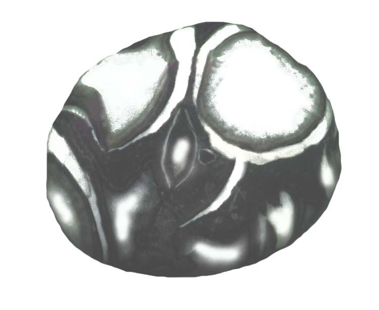
MINERAL OF THE MONTH: January 2009 Sea Shell Jasper

The featured mineral this month is what I call Sea Shell Jasper. Others call it Shell Jasper, or Shell Marble Jasper. It is a new mineral that comes from China. Although it is marketed as jasper, it is actually marble. It has beautiful mottled black, white, and gray colored patterns that appear as a conglomerate group of fossils. However, it is metamorphosed marble consisting of mostly calcite with swirls of limestone, chert, and other impurities. One indicator that this rock is not jasper is that it is relatively soft with a hardness of 4. Despite its softness, it takes a nice polish.

This marbleized “jasper” is valued as a sacred and powerful stone that offers grounding and protection. It can help to invigorate and strengthen your physical, mental, and spiritual being.

History’s Gem of the Month: Old Postcards

January 2009

This month the Gems from the Past include three post cards. I am not sure how and why it occurred, but 100 years ago post cards were often printed showing members of local families. I have included two below of my relatives. My great-grandparents, Jonas and Anna Hill, appear in both pictures. The photo with just the two of them was taken in front of Woodland Park, around 50 feet east of the main entrance. Notice all the trees, as compared to the “Woodless Park,” as my son, Jonathan, now refers to it. My grandparents emigrated from Finland in the late 1890s. Two of their kids (Eino and Emil) were born in Finland. My grandmother Elvi and Uncle Ernie were born in the U.S. The family picture was taken before my Uncle Ernie was born. One thing interesting that I learned while examining these photos, and reading the handwritten information on the back, is that my family’s name before leaving Finland was Maki. I’m not sure why it is, but we were never told that information.

The third post card shows The Vacationland car ferry. This was one of the last two ferries that operated to shuttle vehicles between the lower and upper peninsulas. The state of Michigan began the car ferry service in 1923. It was successful enough, especially as the number of cars on the roads increased dramatically during the 1920s, that the state expended funds to upgrade the ships and improve the docks, breakwaters, and parking at both Mackinaw City and St. Ignace. Each ferry had a regular crew of 36, with up to a hundred extra employees hired during the busy summer months.

By the time the Mackinac Bridge opened for business on November 1, 1957, only two ferries remained including the Vacationland and the Petoskey. On the final day, the Vacationland sailed from St. Ignace to Mackinaw City with about a thousand invitation-only guests.

To pay for the Mackinac Bridge, bonds were sold to fund the project. The agreement that allowed the state to sell the bonds prohibited the operation of any ferries between the two peninsulas. This provision was made to assure bond buyers that the expensive bridge would have no competition. Eventually, all of the ferries were either sold or scrapped.

Today, the Mackinac Bridge carries as many people in a single month as the entire ferry fleet carried in a year. But if it were not for the hardiness of the ferry operators and crew, the Upper Peninsula would not be what it is today.

CURRENT GRAND MARAIS SCENES: January 2009

This has certainly been a winter for many people around the country, Grand Marais included. I have lived here since 1994 and this is the most snow I’ve seen for this time of year. As of about a week ago, our official total was almost 180 inches! It has also been a cold winter, although Grand Marais has not been as cold as some other areas in the U.P. This morning we were around 5 below with a wind chill of 30 below! Other communities were nearly 30 below ambient! Lake Superior is still not frozen very far out – only around a ¼ to ½ mile from shore. The good news is that the warmer waters buffer our temperature. The bad news to some, other than us skiers, is that the difference in temperature (warm lake vs. cold land) creates almost daily lake effect snow.


All of the pictures this month, of course, feature the snow. The first is a shot I took on one of the very few sunny days we have had this winter. It is a picture of the Sucker River in the School Forest. Most of the river is frozen, at least on top. However, the current is swifter in a few places to enable these terrific, high-contract photos.


While in the school forest last week skiing with my friend, Dianna Bell (Bayshore Market), we skied all the way to Goebel Beach. As you rockhounds can see in the next photo looking east from Goebel, there are no rocks to be seen. This is the first time this winter I’ve skied to the lakeshore through the school forest. I was hoping there would be BIG ice bergs, which there were not. There is a lot of float ice, though, that will pile up and form into giant ice bergs if we get a stiff wind from the north.


When I cross country ski with my friends, we usually ski the trails in the national park. These trails and those in the school forest each have their pluses and minuses. The PRNL trails are groomed more frequently, have a wider array of ecosystems, are straighter so you can ski faster, and have more hills. For me, they are also convenient since they are located only a ½ mile from my house. The school forest trails wind along the Sucker River, through expansive fantasy-like pine forests, and with bushwhacking on the snowmobile tracks allow access to the beach east of town. The picture included here was taken from Trail E in the national park, which is located above Sable Falls.


The last picture featured this month was snapped on the south side of my house during a January 17th snow storm. Because my house is located on the top of a glacial terrace hill, the snow blows up the hill and over the roof to deposit on the south side. You can see that the snow on the roof was actually connecting with the ground. The size and length of the “tunnel” of snow covering my house was growing each and every day. Finally, I had to purchase a snow rake and pull the more than 5 feet of snow off my roof. Now the drifts behind my house are even taller – between 10 and 12 feet high covering more than half of the south-side windows!